Product
What Is Ascent EFB? The App, the Company, the Price
August 21, 2026 · 14 min read · by Vincent Wu, Founder, Ascent EFB · Updated August 26, 2026
Try Ascent EFB
Free for 30 days, then $59.99 your first year
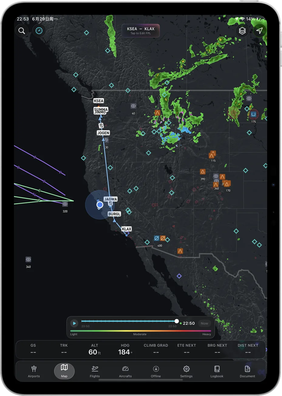
One plan with everything in it: 3D terrain, geo-referenced FAA charts, the full weather stack and live traffic, all cached offline. $89.99 a year after the first. One trial per account, no card needed to look around.
Start a 30-day trialBy Vincent Wu, founder of Ascent EFB. Last updated August 26, 2026.
TL;DR: Ascent EFB is an electronic flight bag app for iPhone and iPad, made by a company called Geospatios and launched in August 2026. It costs $59.99 for the first year and $89.99 a year after that, in one plan with everything in it: 3D terrain, geo-referenced FAA charts including IFR Enroute Low, High and Area, the full weather stack, live traffic, airport info, taxi diagrams, and all of it cached for offline use. It is not a car battery and it is not a flight school. Those are different things that happen to share the name. Every account also gets a one time 30 day Pro trial, so you can fly it before you pay for it.
What is Ascent EFB?
Ascent EFB is an electronic flight bag app for iPhone and iPad, built by Geospatios and launched in August 2026. It costs $59.99 the first year, then $89.99 a year, in one plan that includes 3D terrain, geo-referenced FAA VFR and IFR charts, weather, live traffic, airport information and taxi diagrams, all of it usable offline.
If you searched for "Ascent EFB" and landed somewhere strange, you are not the only one. Google currently reads "EFB" as a battery spec about as often as it reads it as electronic flight bag. So this page exists to say plainly what our app is, who builds it, what it costs, and what it does not do.
At a glance: Ascent EFB next to the two apps you are probably comparing it to
| App | Best for | Key strengths | Price |
|---|---|---|---|
| Ascent EFB | VFR and IFR enroute flying where the shape of the ground matters | 3D terrain, geo-referenced FAA VFR and IFR enroute charts, full weather stack, live traffic, taxi diagrams, everything cached offline, one plan with nothing held back | $59.99 first year, then $89.99/yr |
| ForeFlight | Pilots who fly instrument approaches and want the deepest published toolset | Geo-referenced approach charts and Plates on Maps, Synthetic Vision, Hazard Advisor, Terrain Profile View, logbook on every tier | $130 Starter, $260 Essential, $390 Premium |
| Garmin Pilot | Pilots on Android, or flying behind a Garmin panel | Synthetic vision on the Premium tier, wireless database and flight plan transfer to Garmin navigators, iOS and Android | $109.99 US Standard, $209.98 US Premium |
ForeFlight plan names, prices and tier contents read from foreflight.com/pricing on August 26, 2026. Garmin Pilot US plan names and prices read from Garmin's own published US plan catalog on August 8, 2026. All of it changes without notice, so check the vendor's page before you buy.
What an EFB is, in one paragraph
EFB stands for electronic flight bag. It is the tablet app that replaced the paper sectionals, approach binders and plotter most of us learned to fly with: route planning, geo-referenced charts with your aircraft's position on them, weather, nearby traffic, and airport and taxi information. The FAA uses the term for the whole category. It has nothing to do with batteries.
Why build another EFB at all
The honest answer is not that the incumbents are missing features. Line up the feature rows and ForeFlight and Garmin Pilot have most of what we have, plus a decade of things we do not.
We built Ascent for the same reason somebody built Flighty when flight trackers already existed. A web flight tracker and Flighty technically show you the same flight. Nobody who has used both thinks they are the same product. The data was never the difference. The design was.
EFBs are sitting in that spot now. Most of them were architected a long time ago, and you can feel it in the first thirty seconds: information density tuned for a planning room rather than for one hand on the yoke in light chop, and layers that take four taps to reach when you needed them two minutes ago.
A spec sheet cannot show you any of that. There is no column for how an app reads at 3,000 feet on a hazy afternoon. So instead of arguing about row counts, we would rather point at one specific place where the design difference is visible, and let you go look at it.
The place you can see it: 3D terrain
The thing we built the app around is 3D terrain. Instead of inferring the shape of a ridge from a contour tint and a Maximum Elevation Figure on a flat chart, you see the terrain rendered in three dimensions, so a valley on a hazy afternoon reads as a valley.
The information is not new. The sectional had it. What changes is that you stop spending working memory decoding it, and working memory is the thing that actually runs out in flight. That is the whole argument, and it is not a feature-row argument.
One honest clarification, because it comes up: the terrain is the three-dimensional part. Your own aircraft shows on the map as a 2D heading-up puck, not a 3D model of your airplane.
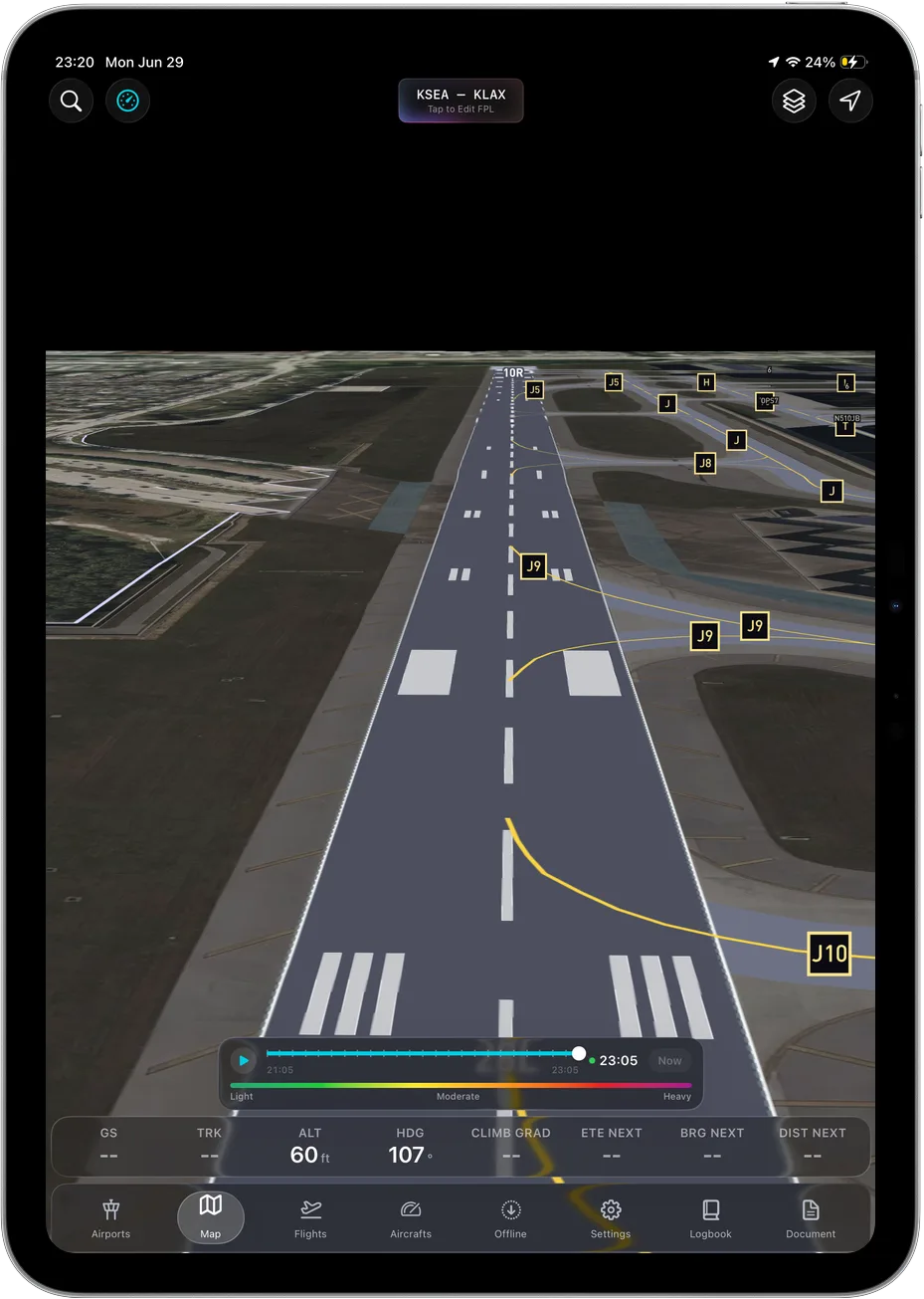 3D terrain is the flagship feature, and it works with no signal at all.
What is actually in the app
Everything below is shipped and in the single plan. There is no higher tier holding any of it.
| Capability | In Ascent EFB |
|---|---|
| 3D terrain | Yes |
| Geo-referenced FAA VFR Sectionals and Terminal Area Charts | Yes |
| IFR Enroute Low, High and Area charts | Yes |
| Weather: METAR, TAF, radar, winds aloft, AIRMET, SIGMET | Yes |
| Live traffic | Yes |
| Airport information | Yes |
| Airport taxi diagrams | Yes |
| Full offline caching of charts, terrain and airport data | Yes |
| Platforms | iPhone and iPad |
Offline deserves its own sentence, because a lot of apps use the word loosely. In Ascent, offline means the whole app. Cache the regions you fly on the ground, put the device in airplane mode, and the charts, the 3D terrain, the airport data and the last weather you pulled all keep working. Most GA ramps in this country have no useful coverage, and the app should not get quieter when the bars do.
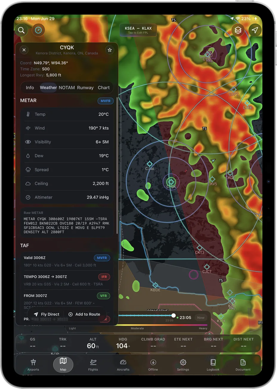 The full weather stack is in the base plan, because there is only one plan.
How the three apps compare, same structure for each
Same four headings for every app, so you can read down the column instead of taking our word for anything.
Ascent EFB
Key features. 3D terrain rendered as terrain rather than as color bands. Geo-referenced FAA VFR Sectionals and Terminal Area Charts. IFR Enroute Low, High and Area charts. The full weather stack: METAR, TAF, radar, winds aloft, AIRMET and SIGMET. Live traffic. Airport information and taxi diagrams. Full offline caching of charts, terrain and airport data, so the app works sealed in airplane mode. iPhone and iPadOS only. Own-ship is a 2D heading-up puck, not a 3D model.
Who it suits. GA pilots flying their own airplanes on an iPad or iPhone. Private pilots doing cross-countries with real ground under them. Students who want one app that is still the right app after the checkride. Instrument pilots who want enroute charts and the full weather stack without buying a second tier to reach them.
Pricing. $59.99 the first year, $89.99 a year after that. One plan, everything included, no add-ons and no tiers.
Sourced note. This is our own product, so the only useful thing we can tell you is what we do not have: no geo-referenced approach plates, no weight and balance, no Android, and a August 2026 launch date instead of a decade of accumulated depth. Verify the rest yourself on the App Store listing.
ForeFlight
Key features. Per foreflight.com/pricing, read August 26, 2026: three personal plans. Geo-Referenced Approaches and Charts plus Plates on Maps appear in Essential and Premium. Synthetic Vision, Hazard Advisor with Automatic Hazard Alerts, and Terrain Profile View with Airspace appear in Essential and Premium. 3D Review appears in Premium only. Pilot Logbook appears on all three tiers.
Who it suits. Instrument pilots who want their aircraft drawn on the approach plate, and anyone who wants the largest published feature surface in general aviation.
Pricing. $130 Starter, $260 Essential, $390 Premium per year, read from foreflight.com/pricing on August 26, 2026.
Sourced note. Everything above comes from ForeFlight's own published pricing page on the date given. If you want the terrain and hazard tooling, the same page puts it at Essential rather than the $130 Starter tier, so price Essential.
Garmin Pilot
Key features. Garmin's own published US plan catalog, read August 8, 2026, lists two US tiers and puts synthetic vision and terrain and obstacle alerts under Premium. Garmin publishes Garmin Pilot on Google Play under the Garmin developer account, checked August 26, 2026, so it runs on Android as well as iOS. Garmin's own Flight Stream 510 material describes Database Concierge moving navigation, obstacle, terrain, SafeTaxi and FliteCharts databases wirelessly between Garmin Pilot and a GTN navigator.
Who it suits. Pilots flying Android tablets, and pilots with Garmin avionics in the panel who want the app and the navigator talking to each other.
Pricing. $109.99 US Standard and $209.98 US Premium, read from Garmin's own published US plan catalog on August 8, 2026.
Sourced note. All of the above is from Garmin's own pages on the dates given. Garmin runs promotions that move the effective price, so read the current catalog rather than this paragraph.
Where ForeFlight still wins
Not a throwaway line. There is one thing ForeFlight does that we simply do not, and it is the thing most likely to matter to you.
Geo-referenced approach plates. ForeFlight's own pricing page, read August 26, 2026, lists Geo-Referenced Approaches and Charts and Plates on Maps in the Essential and Premium tiers. That means your aircraft drawn on the approach chart. Ascent has IFR Enroute Low, High and Area charts, and it does not have geo-referenced plates. If you fly approaches in actual IMC and want own-ship on the plate, that is not a preference, it is a requirement, and ForeFlight meets it today and we do not.
The same page also lists Pilot Logbook on all three ForeFlight tiers and 3D Review on Premium. We have neither.
Where Garmin Pilot still wins
Android, and the panel. Garmin publishes Garmin Pilot on Google Play under the Garmin developer account, checked August 26, 2026. Ascent is iPhone and iPadOS only, and no amount of wanting will change that this year. And per Garmin's own Flight Stream 510 material, Database Concierge moves navigation, obstacle, terrain, SafeTaxi and FliteCharts databases wirelessly between Garmin Pilot and a GTN navigator. If your panel is Garmin, that is a workflow we cannot match.
How we checked this, and our bias
We are biased. Ascent EFB is our app and we would like you to buy it.
So the rule we hold ourselves to is this: every claim about somebody else's product on this page comes from their own published page, with the date we read it, and you can go open the same page and check us. ForeFlight plan names, prices and tier contents were read from foreflight.com/pricing on August 26, 2026. Garmin Pilot US plan names and prices came from Garmin's own published US plan catalog on August 8, 2026, and the Android availability from Garmin's listing on Google Play on August 26, 2026. We do not run comparative bench tests of other people's apps, and if we cannot point you at a source for a competitor limitation, we do not print the claim.
Who makes it: Geospatios
Ascent EFB is built by Geospatios, a software company working on geospatial and aviation tooling. Ascent is our consumer product, the one for pilots flying their own airplanes. We also build AirOS, which is the business-facing side of the same underlying mapping and data work.
Short version: Geospatios is the company, Ascent EFB is the pilot app, AirOS is the commercial platform. If you searched "Geospatios" and were not sure whether that was a company, a product or a typo, that is the answer. Support goes to support@geospatios.com, which is a real mailbox a human reads.
What it costs
$59.99 for the first year. $89.99 a year after that. One plan, everything included, no add-ons and no tiers.
For context on where that sits, see the at a glance table above: ForeFlight publishes $130, $260 and $390 tiers as of August 26, 2026, and Garmin publishes $109.99 and $209.98 US tiers as of August 8, 2026. Prices change, so verify on their pages before you buy. We have written the full breakdown in how much an EFB costs in 2026 and a wider roundup in the best EFB apps of 2026.
The reason we sell one plan is boring and practical: tier matrices make you guess which features you need before you have flown with the app.
Who Ascent EFB is for, and who should buy something else
General aviation pilots flying with an iPad or iPhone. Private pilots flying cross-countries. Students who want one app that will still be the right app after the checkride. Instrument pilots who want enroute charts and weather without buying a second tier to get them. Anyone flying somewhere with real rocks around it, which is where the 3D terrain earns its keep.
Now the other direction, because filtering you out is cheaper for both of us than a refund:
- Choose ForeFlight if you fly instrument approaches in actual IMC and want your aircraft drawn on the plate. Their own pricing page puts geo-referenced approach charts in Essential and above, read August 26, 2026. We do not have that capability at any price.
- Choose Garmin Pilot if you fly an Android tablet, or if your panel is Garmin and you want databases and flight plans moving between the app and the navigator.
- Choose whatever your flight department standardised on, because losing that argument costs more than a subscription.
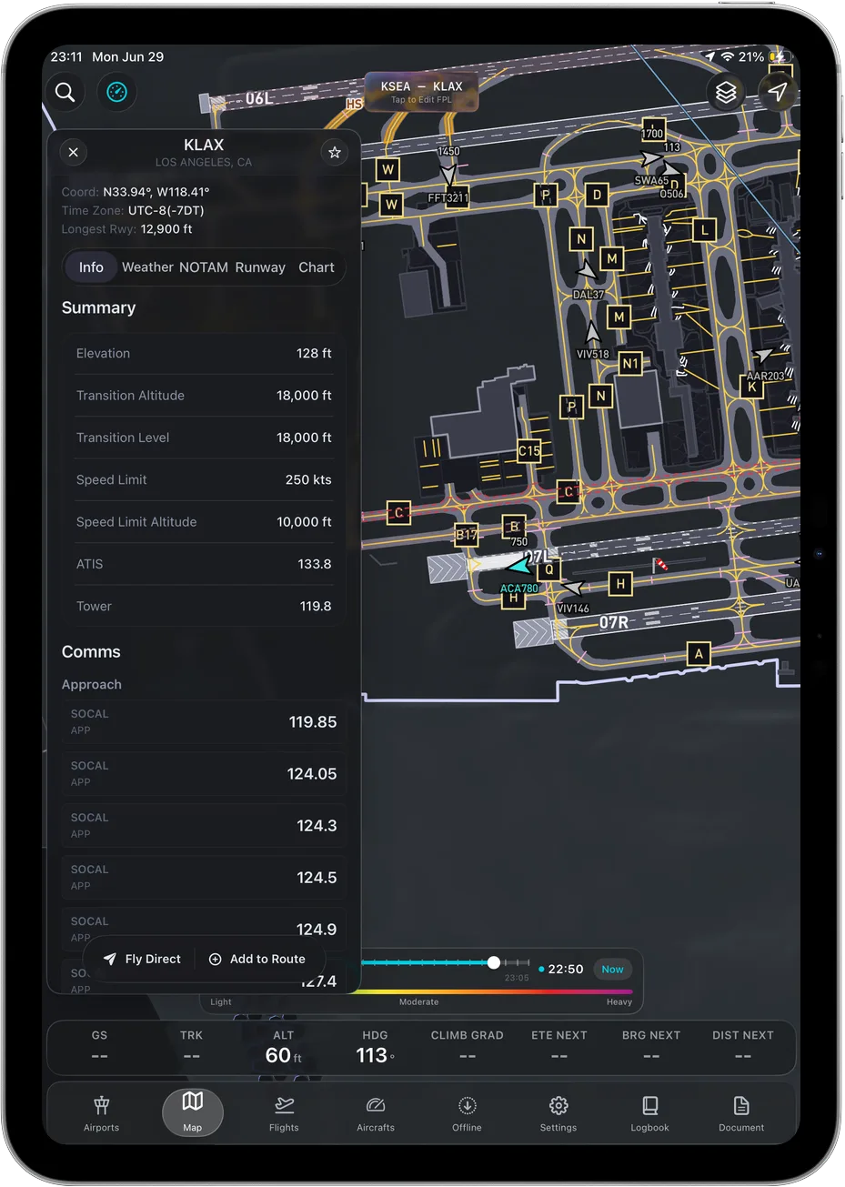 Taxi diagrams and airport info, cached with everything else.
What Ascent EFB does not have
This part matters more than the feature list, because it is where marketing pages usually lie.
- No geo-referenced approach charts. Enroute IFR yes, own-ship on the plate no.
- No weight and balance.
- No Android version. iPhone and iPad only. If you fly with an Android tablet, Garmin publishes Garmin Pilot on Google Play, checked August 26, 2026, and that is a real answer we would rather give you than pretend.
- No free tier. One paid plan, discounted the first year instead.
If you were looking for something else called Ascent
Three different things share this name, and search engines mix them up constantly.
- Subaru Ascent. That is a three-row SUV. In car-parts listings, "EFB" means Enhanced Flooded Battery, a starter battery type. Completely unrelated to us. If you need a battery for your Ascent, you want an auto parts retailer, not an aviation app.
- Ascent Flight Training. That is a UK-based military flight training organisation. Also unrelated to us. Different country, different business, no connection.
- Ascent EFB by Geospatios. That is this one. An iOS and iPadOS electronic flight bag app for pilots, launched August 2026.
We are not claiming the name. We are just trying to make sure the pilot who wanted the app finds the app.
How to get it
Ascent EFB is on the App Store for iPhone and iPad: apps.apple.com/us/app/ascent-efb/id6756762115. The discounted first year is roughly the cost of an hour of dual, which is the cheapest way to find out whether the terrain view does for you what it does for us.
If you are still comparing, read Ascent EFB vs ForeFlight and our guide on how to choose an EFB.
Frequently asked questions
What is Ascent EFB?
Ascent EFB is an electronic flight bag app for iPhone and iPad from Geospatios, launched in August 2026. It provides 3D terrain, geo-referenced FAA VFR and IFR charts, weather, live traffic, airport information and taxi diagrams, all usable offline, in a single plan.
Who makes Ascent EFB?
Geospatios, a geospatial and aviation software company. Geospatios also builds AirOS, the business-facing platform.
How much does Ascent EFB cost?
$59.99 for the first year and $89.99 a year after that. One plan, everything included.
Does Ascent EFB work on Android?
No. It is iPhone and iPad only, and we would rather say that plainly than let you find out after paying. Garmin publishes Garmin Pilot on Google Play if Android is a requirement, checked August 26, 2026.
Does Ascent EFB work offline?
Yes. Charts, 3D terrain and airport data cache to the device, and the last weather you pulled stays available, so the app works in airplane mode.
How is Ascent EFB different from ForeFlight and Garmin Pilot?
Mostly not by feature count. The feature rows overlap heavily and the incumbents have depth we do not. The difference is in how the app reads in the cockpit, and the clearest example is 3D terrain, which shows you the shape of the ground instead of asking you to reconstruct it from contour lines and elevation numbers.
Is Ascent EFB related to the Subaru Ascent or to Ascent Flight Training?
No. The Subaru Ascent is an SUV, and "EFB" in car listings means Enhanced Flooded Battery. Ascent Flight Training is a UK military flight training organisation. Ascent EFB is an aviation app made by Geospatios and has no connection to either.
Written by Vincent Wu, founder of Ascent EFB at Geospatios. Ascent EFB is our product, so treat our opinions about it as ours. ForeFlight plan names, prices and tier contents were read from foreflight.com/pricing on August 26, 2026. Garmin Pilot US subscription prices were read from Garmin's own published US plan catalog on August 8, 2026, and Android availability from Garmin's listing on Google Play on August 26, 2026. All of it changes over time, so verify before you buy. Any EFB is a supplemental aid to situational awareness, and final authority rests with the pilot in command.
Try Ascent EFB
Free for 30 days, then $59.99 your first year
One plan with everything in it: 3D terrain, geo-referenced FAA charts, the full weather stack and live traffic, all cached offline. $89.99 a year after the first. One trial per account, no card needed to look around.
Start a 30-day trial