Training
How to Debrief a Training Flight From GPS Data
November 10, 2026 · 10 min read · by Vincent Wu, Founder, Ascent EFB
Covers features arriving in Ascent 1.9.6. The App Store build today is 1.8.
Try Ascent EFB
Free for 30 days, then $59.99 your first year
One plan with everything in it: 3D terrain, geo-referenced FAA charts, the full weather stack and live traffic, all cached offline. $89.99 a year after the first. One trial per account, no card needed to look around.
Start a 30-day trialBy Vincent Wu, founder of Ascent EFB. Published November 10, 2026.
TL;DR: A useful debrief checks what you can measure: whether each approach was stable at 1,000 ft and 500 ft above the field, how the final compared with a 3° path, and where you touched down against the Private Pilot ACS (within 400 ft beyond the specified point for a normal landing, 200 ft for short-field). A GPS track can estimate all of that. It cannot see airspeed, attitude, power or flaps, so it supports your CFI and never replaces them. Ascent 1.9.6, rolling out now, records the track, replays it in 3D over terrain and builds this debrief, labelled as estimates. The App Store build today is 1.8.
How do you debrief a flight from GPS data?
Record the track, then check three things on every approach: was it stabilized by 500 ft above the field (the Airplane Flying Handbook's go-around point in visual conditions), how did the final descent compare with a 3° glidepath, and did you touch down within the ACS tolerance of 400 ft beyond your chosen point (200 ft for short-field). Treat every number as an estimate: GPS gives groundspeed and GPS height, not airspeed or attitude.
What a good debrief covers
Most lessons end with "landings were a bit long," judged on the last approach. A recorded track lets you and your CFI look at the whole lesson instead. The goal is not a grade but one or two things to change next time, and this structure works with any tool, from an app to a GPX file to a whiteboard:
- The plan against what happened. If the lesson was short-field landings, judge short-field landings.
- Pattern geometry. Downwind spacing, where base started, how long the final was.
- Each approach at its gates. Descent rate, speed and alignment at 1,000 ft and 500 ft above the field.
- Glidepath. Steep, shallow or close to 3°, and whether corrections came early or late.
- Touchdown. How far past the threshold, how firm, how close to the centerline.
- Go-arounds. Why, and how early. Going around from an unstable approach is a good outcome.
- One or two takeaways. Not ten.
The stabilized approach, with the numbers
The FAA's Airplane Flying Handbook (FAA-H-8083-3C, chapter 9) defines a stabilized approach as a constant-angle glide path toward a predetermined point on the runway, flown at a constant final descent airspeed and configuration. For a typical piston airplane it lists these elements:
- Glide path: typically a constant 3 degrees to the touchdown zone, obstructions permitting.
- Heading: tracking the centerline with minor corrections, bank normally limited to 15 degrees once established on final.
- Airspeed: within +10/-5 knots of the recommended landing speed (AFM, 1.3 VSO or placards).
- Configuration: landing configuration and in trim.
- Descent rate: generally 500 to 1,000 fpm for light GA airplanes, and reduced before 300 ft AGL if it was above 500 fpm.
- Power: appropriate to the configuration, not below the AFM minimum.
- Briefings and checklists: done before the approach, except the landing checklist.
The same chapter gives the gate: pilots typically go around if not stabilized by 500 ft above airport elevation in VMC, or 1,000 ft in IMC, and in a GA piston pattern an approach that becomes unstabilized below 300 ft AGL calls for an immediate go-around. It also says to focus on what produces a stable approach rather than insisting on every criterion.
So 500 ft is the gate that matters in a VFR pattern. 1,000 ft is the instrument standard, and in a normal VFR pattern you are usually still on downwind or base when you pass it. Both are worth a look: messy at 1,000 ft and tidy at 500 ft means the corrections worked; fine at 1,000 ft and falling apart at 500 ft is a different lesson.
Glidepath against a 3° reference
A 3° path drops about 320 ft per nautical mile, which is the FAA Safety Team's "3:1" rule: roughly 1,000 ft for every 3 nm over the ground. Its fact sheet adds the descent rate shortcut: groundspeed in knots times 5 gives roughly the fpm for a 3° path, so about 350 fpm at 70 knots.
The angle is measured over the ground, so a headwind on final shows up as a lower groundspeed and a lower descent rate on the same path, not a different one. And the profile separates two mistakes that can end in the same long landing: a steep final, usually from a high base or a late descent, and a shallow, dragged-in final, usually from power added late to fix a low approach.
Some runways have a visual glideslope set steeper than 3°, and obstacles can justify a steeper path, so 3° is a reference to compare against, not a rule.
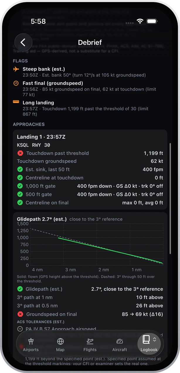 Solid line: the flown path from GPS height above the threshold. Dashed line: a 3° path through 50 ft over the threshold.
Touchdown against the ACS
The Private Pilot Airplane ACS (FAA-S-ACS-6C) sets the touchdown standard:
- Normal approach and landing (PA.IV.B.S10): touch down at a proper pitch attitude, within 400 ft beyond or on the specified point, with no side drift, aligned with and over the runway centerline.
- Short-field approach and landing (PA.IV.F.S10): within 200 ft beyond or on the specified point, threshold markings or runway numbers, with no side drift and minimum float.
The weak link is "the specified point." You or the examiner choose it, and no track knows what you chose, so decide it before the flight and measure against it afterward.
The handbook's guidance for a normal landing is to land in the center of the first third of the runway, and its short-field section names the usual reason for missing: excess airspeed can put the touchdown too far from the threshold. AC 91-79B, the FAA's advisory circular on landing performance and runway excursions, is the longer read on what a long, fast touchdown costs.
What GPS data can and cannot tell you
| A GPS track can estimate | A GPS track cannot measure |
|---|---|
| Position, ground track and groundspeed | Indicated or true airspeed |
| Height above the field, from GPS altitude and field elevation | Pitch, bank or any attitude directly |
| Descent rate, fitted over a few seconds | Power setting or flap position |
| Bank angle, inferred from turn rate and groundspeed | Where you were looking, or what you were thinking |
| Touchdown point and centerline offset, once the runway is identified | The point you or your examiner specified |
GPS vertical accuracy is worse than horizontal, so a few tens of feet of height error is normal for a tablet in a cockpit. Small differences mean nothing; trends across several approaches, and big misses, mean a lot. None of this is certified flight data.
How Ascent 1.9.6 does it
Everything below arrives in Ascent 1.9.6, rolling out now. The App Store build today is 1.8.
Recording. From the device's GPS, an ADS-B receiver's GPS, or Infinite Flight, with simulator tracks tagged SIM. Use Record and Stop, or let it pick up the flight. After landing, a "Flight detected" card offers Log flight (a logbook entry in one tap) or Replay. A real flight keeps recording with the iPad locked or another app in front.
3D replay. The flight plays over 3D terrain at 1×, 4× or 16×, with Chase and Overhead cameras, altitude, groundspeed and track tapes, and an altitude and groundspeed profile. Debrief flags sit on the scrubber; tap one to jump there.
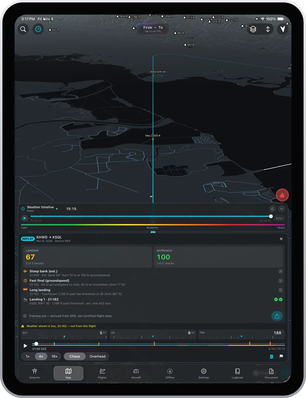 The replay with the debrief card open.
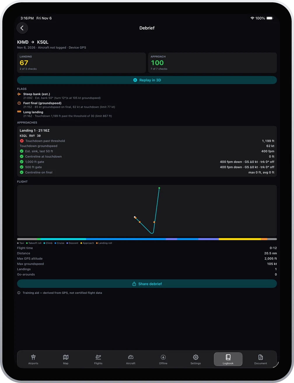
The debrief. From the track alone Ascent finds the flight phases, each touchdown, touch-and-go and go-around, and the runway. For every approach it shows:
- the 1,000 ft and 500 ft gates: descent rate, groundspeed steadiness, track against the runway
- touchdown distance past the threshold, groundspeed, estimated sink over the last 50 ft, centerline offset
- glidepath against the 3° reference, and your height above or below it at 1 nm and 0.5 nm
- pattern geometry: side, downwind spacing, where base started
- ACS checks for pattern altitude and the 400 ft and 200 ft touchdown tolerances
Flags cover steep bank (estimated), high descent rate, low altitude away from an airport, a fast final by groundspeed and a long landing. A Landing score and an Approach score count checks passed, for example "2 of 3 checks". Go-arounds are marked as decisions and never scored, because going around from an unstable approach is the right call. Labels say what each value is: groundspeed, GPS height, est. bank, est. sink.
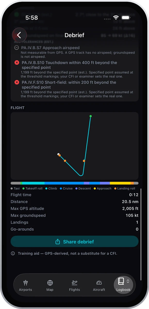 Approach airspeed is marked "Not measurable from GPS" rather than guessed.
Coaching tips. Each finding gets a short note on how to improve, citing FAA public-domain sources: the Airplane Flying Handbook, the Pilot's Handbook of Aeronautical Knowledge, the ACS, the AIM and AC 91-79B. Coaching is off by default and switches on by itself when your Ascent logbook shows a current student pilot certificate or a student solo endorsement under 14 CFR 61.87. Your own choice in Settings always wins.
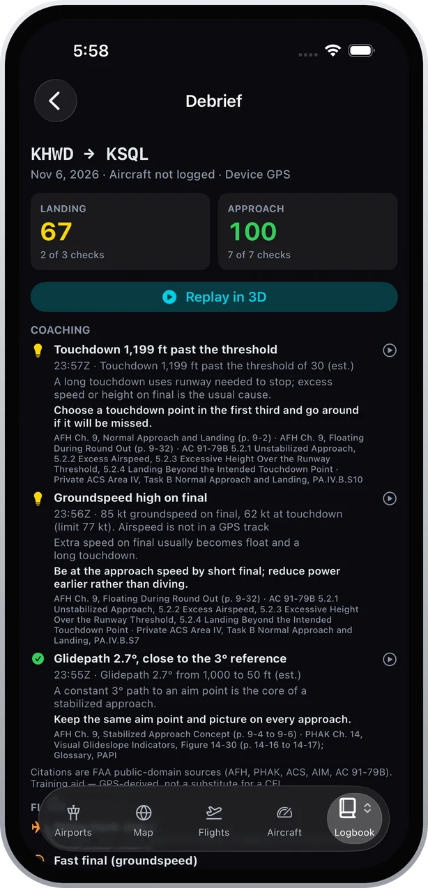
Sharing. Share debrief writes a PDF on the device for your CFI: scores, a track map, the approaches and the flags, plus a page with the glidepath chart and ACS lines when an approach has a straight final to measure. Tracks also export as GPX, KML and a CloudAhoy-format CSV.
The debrief screen, the replay's debrief card and every PDF page carry the same line: a training aid, GPS-derived, not a substitute for a CFI.
The limits, honestly
- The specified point is assumed. Ascent measures the ACS tolerances from the threshold markings and says so on the check. If your CFI chose a point further down the runway, the results read long.
- The 1,000 ft gate expects a straight-in. It checks track against the runway heading, so in a VFR pattern, where you are usually on downwind or base at that height, it will often show the track check missed. Use the 500 ft gate as your VFR standard.
- No runway, no score. A touchdown that cannot be matched to one runway is listed but not scored.
- Small deviations are not called out. Under 75 ft off the 3° reference at 1 nm or 0.5 nm is shown but treated as GPS vertical error.
- Bank and sink are inferred, bank from turn rate and groundspeed, and not below 40 knots.
- "Fast final" is relative to your own touchdown groundspeed, because no airspeed or aircraft type is recorded. It is not a comparison with a published approach speed.
How to run the debrief with your CFI
- Before the flight, agree the lesson objective and the specified touchdown point for each landing type.
- Start recording before taxi so the track includes the whole pattern.
- After landing, log the flight from the prompt and open the replay while it is fresh.
- Watch each approach at 4× in Chase and pause at the 500 ft gate. Ask what the airspeed and configuration were; the track cannot answer that, but you and your CFI can.
- Compare the glidepath across all the approaches, not just the worst one.
- Check touchdown against the point you agreed, not against the threshold, if they differ.
- Agree one or two changes for next lesson and write them in the logbook remarks.
- Share the PDF so your CFI can compare it with the next lesson's.
Sources
- FAA, Airplane Flying Handbook (FAA-H-8083-3C), Chapter 9, Approaches and Landings: faa.gov
- FAA, Private Pilot for Airplane Category Airman Certification Standards (FAA-S-ACS-6C), Area IV Tasks B and F, Area III Task B: faa.gov
- FAA, AC 91-79B, Aircraft Landing Performance and Runway Excursion Mitigation: faa.gov
- FAA Safety Team, Stabilized Approach and Landing fact sheet (AFS-850 20-04): faasafety.gov
Written by Vincent Wu, founder of Ascent EFB at Geospatios. FAA guidance and ACS tolerances were checked against FAA-published text on November 10, 2026. The features described arrive in Ascent 1.9.6, rolling out now; the App Store build today is 1.8, and Ascent requires iOS 18.0 or later. Ascent is one plan, $59.99 the first year, then $89.99 a year, with a one-time 30-day Pro trial. The debrief is a training aid derived from GPS, not certified flight data and not a substitute for a CFI. Final authority rests with the pilot in command.
Try Ascent EFB
Free for 30 days, then $59.99 your first year
One plan with everything in it: 3D terrain, geo-referenced FAA charts, the full weather stack and live traffic, all cached offline. $89.99 a year after the first. One trial per account, no card needed to look around.
Start a 30-day trial