Features
What 3D Terrain Does for Situational Awareness
August 21, 2026 · 14 min read · by Vincent Wu, Founder, Ascent EFB · Updated August 26, 2026
Try Ascent EFB
Free for 30 days, then $59.99 your first year
One plan with everything in it: 3D terrain, geo-referenced FAA charts, the full weather stack and live traffic, all cached offline. $89.99 a year after the first. One trial per account, no card needed to look around.
Start a 30-day trialBy Vincent Wu, founder of Ascent EFB. Last updated August 26, 2026.
TL;DR: A sectional gives you elevation as numbers and color bands and asks your brain to turn that into a shape. 3D terrain skips the translation and shows you the ridge. That matters most in mountains, at night, into unfamiliar fields and on circling approaches. It is not a terrain warning system and it does not replace the chart or looking outside. Ascent EFB includes 3D terrain in its one plan, $59.99 the first year and $89.99 a year after, and it works with the iPad in airplane mode. Every account also gets a one time 30 day Pro trial, so you can fly it before you pay for it.
What does 3D terrain actually do for situational awareness?
3D terrain renders the ground as a shape instead of encoding it as contour lines and elevation numbers, so you read a ridge at a glance rather than reconstructing it in your head. It helps most in mountains, at night and into unfamiliar fields. It is not TAWS and does not replace the chart.
Quick context if you landed here cold: Ascent EFB is an electronic flight bag app for iPhone and iPad, built by Geospatios and launched in August 2026. Not a car battery, not a flight school. An EFB.
At a glance: how the three main iPad EFBs handle terrain
| App | Best for | Key strengths on terrain | Price |
|---|---|---|---|
| Ascent EFB | Reading the shape of the ground at a glance, on any flight | 3D terrain in the only plan there is, cached offline with charts and airport data, nothing gated behind a higher tier | $59.99 first year, then $89.99/yr |
| ForeFlight | Pilots who want terrain tooling plus alerting and instrument depth | Synthetic Vision, Hazard Advisor with Automatic Hazard Alerts and Terrain Profile View with Airspace in Essential and Premium; 3D Review in Premium | $130 Starter, $260 Essential, $390 Premium |
| Garmin Pilot | Pilots on Android or behind a Garmin panel | Synthetic vision and terrain and obstacle alerts on the Premium tier | $109.99 US Standard, $209.98 US Premium |
ForeFlight plan names, prices and tier contents read from foreflight.com/pricing on August 26, 2026. Garmin Pilot US plan names, prices and tier contents read from Garmin's own published US plan catalog on August 8, 2026. Vendors move both without notice, so check their page before you spend money.
What a 2D chart is actually asking you to do
Open a sectional over anywhere with real rocks and what you get is a set of encodings: contour lines you read as a rate of change, hypsometric tints that are elevation buckets rendered as color, Maximum Elevation Figures at one number per quadrangle, spot elevations on peaks, obstacle symbols with AGL and MSL stacked next to them.
Every one of those is accurate. None of them is a picture. To use them you run a small piece of mental software: read the number, subtract your altitude, hold the result, look at where the contours bunch, decide whether the valley you are in goes somewhere or ends in a wall.
That software works fine in the flight planning room. It degrades exactly when you need it: hand flying in turbulence, talking to Approach, at night, tired at the end of a long leg. Controlled flight into terrain is still one of the ways current, well equipped, experienced pilots die, and it is almost never because someone did not know the mountain was there. It is because the picture in their head did not match the ground.
What changes when you can see the ridge
3D terrain does the translation for you. Instead of a chart that encodes elevation you get a rendered surface: the valley has walls, the ridge has a top, and the ground between you and the airport either rises or it does not.
| The question | On a 2D chart | On 3D terrain |
|---|---|---|
| Is that ridge above me? | Read MEF, subtract altitude, hold the number | Look at whether it is above the horizon |
| Does this valley go through? | Trace contours, infer the saddle | See the saddle, or see that there is not one |
| What is under the final segment? | Cross reference spot elevations along the leg | Look along the route |
| How much room do I have on the circling side? | MSA plus chart study plus imagination | Look at the shape of the ground |
The gain is not new information. The chart had it. The gain is getting it without spending working memory, and working memory is the resource that actually runs out in flight.
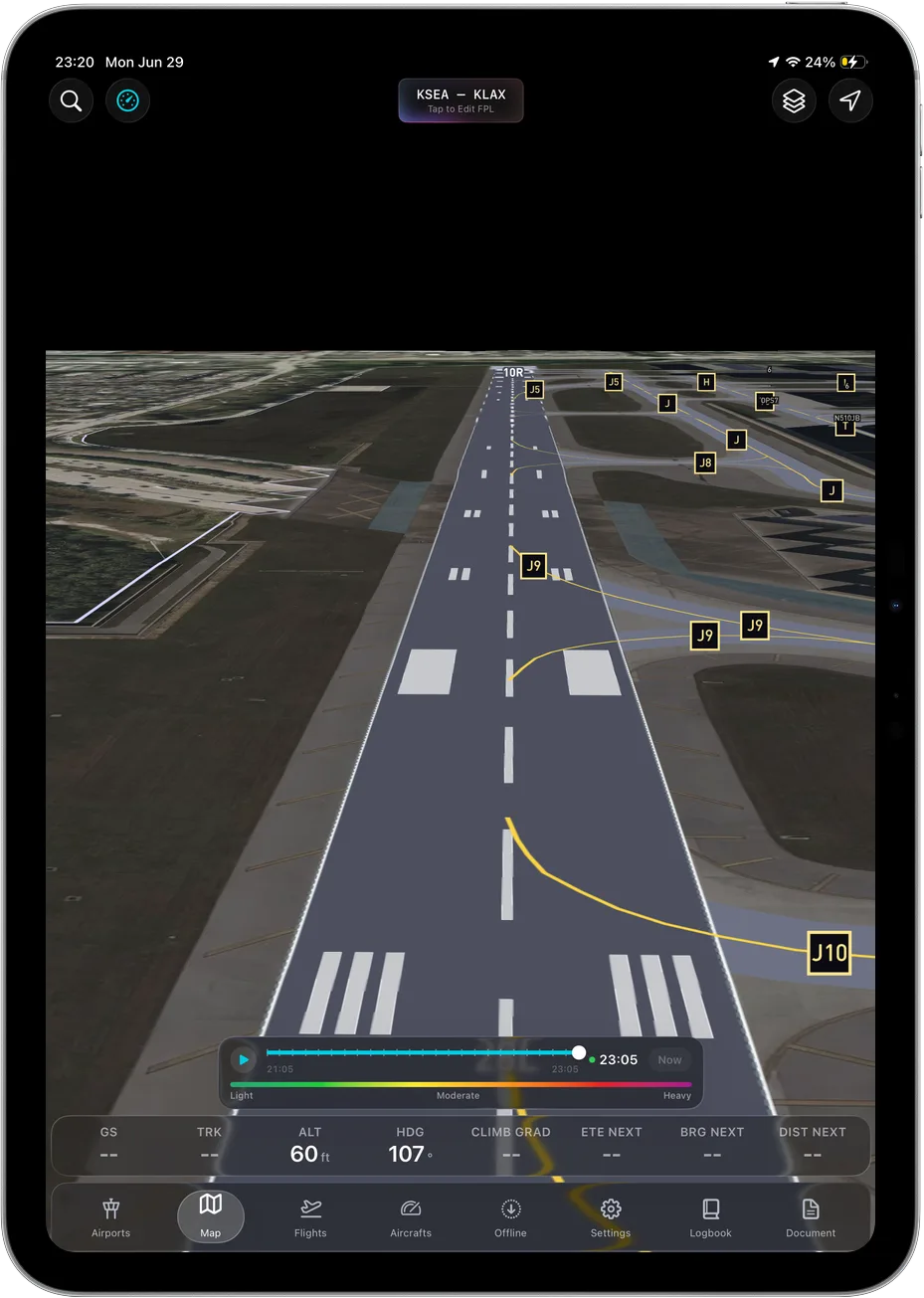 The ridge as a shape instead of a number. This view works with no signal at all.
Why this is the thing worth arguing about, and feature counts are not
Every EFB worth naming has a terrain row on its feature list. Ours, ForeFlight's, Garmin's. If you were choosing on rows you would flip a coin.
But a feature list is a terrible description of a tool you hold in one hand at 3,000 feet. It is the same problem as flight tracking: a web flight tracker and Flighty technically show you the same flight, and nobody who has used both has ever thought they were the same product. The data was identical. The design was not, and the design is the entire experience.
Most EFBs were architected a long time ago, and terrain in them tends to be a layer you enable rather than a picture you fly with. That distinction never appears in a comparison table, because tables count capabilities and cannot measure how long it takes you to answer "will I clear that."
Which is why we are not going to argue that we have more terrain features than ForeFlight. We do not. We are going to argue that terrain is the one place where the difference in how these apps were designed is visible in about four seconds, and that you should go look at it rather than read anyone's table, ours included.
Where it earns its place
Mountain flying. Route selection through passes, deciding early whether a canyon is a through route or a box. The classic mountain accident is a slow, reasonable sequence of decisions ending with an aircraft that cannot outclimb the ground. Seeing shape instead of numbers moves your decision point earlier, and that is the only part of the sequence you get to change.
Night. The outside picture goes away and the terrain does not. A black hole departure out of a valley airport is exactly the case where your scan is busy and your visual reference is a few lights. A rendered surface next to you replaces a reference you genuinely do not have.
Unfamiliar fields. Locals at any strip with terrain around it have a model built over years: which side you do not turn toward, where the ground comes up, which downwind is the one you want. You do not have that on your first arrival, and ten minutes with 3D terrain the night before is the closest thing to borrowing it.
Circling approaches. Low, configured, maneuvering visually, close to the ground, possibly on the side of the field you have never seen. Chart study still comes first, and so do the MSA and the published circling area. But knowing what the ground does on the circling side, as a shape you already looked at, is a real reduction in surprise.
What it is not
We would rather be straight about this than sell you something.
3D terrain in an EFB is not TAWS. It has none of the certification, alerting logic or authority of a terrain awareness and warning system, and you should not fly toward rocks expecting it to shout. It is a picture, not a guard.
It is also not the chart. The chart carries airspace, minimum altitudes, obstacles and everything else published. 3D terrain sits alongside your geo-referenced VFR and IFR charts, not in front of them.
One thing we will not oversell: in Ascent your own aircraft shows as a 2D heading up puck, not a 3D model of your airplane. The terrain is the three dimensional part. An EFB is a supplemental aid, final authority is the pilot in command, and in visual conditions the primary terrain sensor is the window.
The three apps, same four headings each
Ascent EFB
Key features. 3D terrain as the flagship, rendered as ground rather than as color bands, and included in the only plan there is. Alongside it: geo-referenced FAA VFR Sectionals and Terminal Area Charts, IFR Enroute Low, High and Area charts, METAR, TAF, radar, winds aloft, AIRMET and SIGMET, live traffic, airport information and taxi diagrams. Full offline caching covers the terrain, the charts and the airport data, so the picture is still there in a valley with no coverage. Own-ship is a 2D heading-up puck. iPhone and iPadOS only.
Who it suits. Pilots who fly where the ground is a factor and who would rather see a ridge than compute one. Students and private pilots who do not want to work out which tier holds the terrain layer.
Pricing. $59.99 the first year, then $89.99 a year. One plan, no tiers, no add-ons.
Sourced note. Ours, so take the opinions as ours and the omissions as the useful part: no geo-referenced approach charts, no weight and balance, no Android, no alerting layer of any kind, and a August 2026 launch rather than a decade of depth.
ForeFlight
Key features. Per foreflight.com/pricing, read August 26, 2026: Synthetic Vision, Hazard Advisor with Automatic Hazard Alerts, and Terrain Profile View with Airspace all sit in the Essential and Premium tiers. 3D Review sits in Premium only. Geo-Referenced Approaches and Charts also sit in Essential and above.
Who it suits. Pilots who want terrain depiction plus an automatic alerting layer, and instrument pilots who want own-ship on the plate.
Pricing. $130 Starter, $260 Essential, $390 Premium per year, read from foreflight.com/pricing on August 26, 2026.
Sourced note. All of the above is ForeFlight's own published pricing page on that date. The practical implication from their page: if terrain is why you are buying, the $130 Starter tier is not the one you want.
Garmin Pilot
Key features. Garmin's own published US plan catalog, read August 8, 2026, lists two US tiers and puts synthetic vision and terrain and obstacle alerts under Premium. Garmin publishes Garmin Pilot on Google Play under the Garmin developer account, checked August 26, 2026, so Android is covered.
Who it suits. Pilots on Android tablets, and pilots with Garmin avionics who want the app and the panel connected.
Pricing. $109.99 US Standard and $209.98 US Premium, read from Garmin's own published US plan catalog on August 8, 2026.
Sourced note. From Garmin's own pages on the dates given. Garmin runs promotions that move the effective price, so read the live catalog.
Where ForeFlight still wins
On terrain specifically, and this is a real gap rather than a polite one.
Alerting. ForeFlight's own pricing page, read August 26, 2026, lists Hazard Advisor with Automatic Hazard Alerts in Essential and Premium. Ascent's 3D terrain shows you the ground; it does not watch it for you and it does not raise an alert. If you want the app to interrupt you, ForeFlight publishes that and we do not.
Terrain Profile View with Airspace, also Essential and above on that page, gives you a vertical slice along the route with airspace on it. That is a genuinely different and useful way to look at terrain and we have no equivalent.
3D Review, Premium only on the same page, replays the flight in three dimensions afterwards. Debriefing a mountain leg that way is a good habit and we do not offer it.
And the broader one: geo-referenced approach charts sit in Essential and above on ForeFlight's page. Ascent does not have them.
Where Garmin Pilot still wins
Garmin's own published US plan catalog, read August 8, 2026, puts terrain and obstacle alerts under the Premium tier, which is again an alerting capability we do not have. And Garmin publishes Garmin Pilot on Google Play, checked August 26, 2026, so if your tablet is Android the decision is already made for you.
How we checked this, and our bias
We are biased. Ascent EFB is our app and we would like you to buy it, and this whole post is an argument for the feature we built the company around.
So every claim about somebody else's product here comes from their own published page with the date we read it, and you can open the same page and check us. ForeFlight tier contents and prices were read from foreflight.com/pricing on August 26, 2026. Garmin Pilot US tier contents and prices came from Garmin's own published US plan catalog on August 8, 2026, and Android availability from Garmin's listing on Google Play on August 26, 2026. We do not run bench tests of competitor apps, and when we cannot source a competitor limitation we cut the sentence rather than soften it.
How this sits in Ascent
We built Ascent around terrain, so it is in the one plan there is. No tier above it, nothing to upgrade to, no discovering mid flight that the layer you want belongs to a different subscription. $59.99 the first year, $89.99 a year after, and that is the whole app: 3D terrain, geo-referenced FAA charts including IFR Enroute Low, High and Area, full weather with METAR, TAF, radar, winds, AIRMET and SIGMET, live traffic, airport info and taxi diagrams.
The part that matters more than it sounds is that it all caches offline. Terrain that only renders with bars goes missing on exactly the flights where terrain matters. Cache the region on the ground and the picture is still there in the mountains with no coverage, which is most mountains.
Ascent is iPhone and iPad only. No Android app. We would rather say that here than have you find out after paying.
Buy the other one if: you want an app that alerts you about terrain rather than shows it to you, or you fly instrument approaches and want own-ship on the plate. ForeFlight publishes both, per their pricing page read August 26, 2026, and neither is on our roadmap to announce today. Ascent is the right answer if what you want is to look at the ground and understand it immediately.
The fuller side by side is in Ascent EFB vs ForeFlight, and if you are still working out what you need, start with how to choose an EFB or the best EFB apps roundup.
How to actually practice with it
Terrain awareness is a habit, not a feature you buy. Three things that work:
- Fly a route you know well and look at it in 3D first. You will find at least one place where your mental picture was wrong. Everyone does.
- Brief the diversion fields too, and unfamiliar destinations the night before. Thirty seconds each.
- Put the device in airplane mode on the ramp and confirm the terrain you cached is really there before you need it.
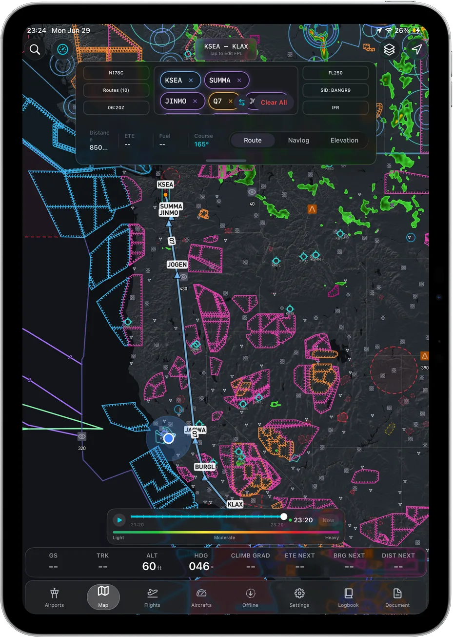 Terrain sits alongside charts, airspace and weather, not instead of them.
Ascent EFB is on the App Store for iPhone and iPad: apps.apple.com/us/app/ascent-efb/id6756762115. Pull up a route you know and see whether the ridge reads faster than the contour lines did. That is the whole pitch.
Frequently asked questions
Does 3D terrain replace a TAWS?
No. It has no certification, no alerting authority and no guaranteed callouts. It is a situational awareness picture that supplements the chart and looking outside.
Is 3D terrain in the base Ascent EFB plan?
Yes. Ascent has one plan, $59.99 the first year and $89.99 a year after, and 3D terrain is in it along with charts, weather, live traffic, airport info and taxi diagrams.
Does 3D terrain work offline?
Yes. Cache the regions you fly while you are on the ground and the terrain renders in airplane mode, along with your charts and airport data.
Does Ascent show a 3D model of my airplane?
No. Own-ship is a 2D heading up puck. The terrain is the three dimensional part, and we are not going to imply otherwise.
Does Ascent EFB alert me about terrain the way ForeFlight's Hazard Advisor does?
No. ForeFlight's own pricing page, read August 26, 2026, lists Hazard Advisor with Automatic Hazard Alerts in Essential and Premium. Ascent shows terrain, it does not alert on it. If you want an alerting layer, buy the one that publishes it.
What is Ascent EFB?
Ascent EFB is an electronic flight bag app for iPhone and iPad from Geospatios, launched in August 2026: 3D terrain, geo-referenced VFR and IFR charts, weather, live traffic, airport info and taxi diagrams, all offline, in one plan.
Written by Vincent Wu, founder of Ascent EFB at Geospatios. ForeFlight plan names, prices and tier contents were read from foreflight.com's published pricing page on August 26, 2026. Garmin Pilot US plan names, prices and tier contents were read from Garmin's own published US plan catalog on August 8, 2026, and Android availability from Garmin's listing on Google Play on August 26, 2026. All of it changes over time, so verify it yourself. Ascent is our product, so treat our opinions as ours. Any EFB, including this one, is a supplemental aid and is not a certified terrain awareness and warning system. Final authority rests with the pilot in command.
Try Ascent EFB
Free for 30 days, then $59.99 your first year
One plan with everything in it: 3D terrain, geo-referenced FAA charts, the full weather stack and live traffic, all cached offline. $89.99 a year after the first. One trial per account, no card needed to look around.
Start a 30-day trial