Guides
Best EFB for Mountain Flying in 2026: Terrain, Winds, Offline
August 21, 2026 · 16 min read · by Vincent Wu, Founder, Ascent EFB · Updated August 26, 2026
Try Ascent EFB
Free for 30 days, then $59.99 your first year
One plan with everything in it: 3D terrain, geo-referenced FAA charts, the full weather stack and live traffic, all cached offline. $89.99 a year after the first. One trial per account, no card needed to look around.
Start a 30-day trialBy Vincent Wu, founder of Ascent EFB. Last updated August 26, 2026.
TL;DR: Mountain flying puts pressure on four things in an EFB: how honestly it draws terrain, whether it gives you winds aloft you can act on, whether the app survives a valley with no signal, and how fast you can pick out an escape route. Most EFBs are fine on flat ground. The mountains sort them out. Ascent EFB is $59.99 the first year and $89.99 after, one plan, with 3D terrain and full offline caching included, which is why we think it holds up here. ForeFlight publishes three tiers, and per their pricing page on August 26, 2026 the terrain-focused features sit in Essential and above rather than the $130 Starter plan. Every account also gets a one time 30 day Pro trial, so you can fly it before you pay for it.
What is the best EFB for mountain flying?
In the mountains an EFB has to do four things: draw terrain you can read at a glance, give you winds at pass altitude, keep working with no cell signal, and make escape routes obvious. Ascent EFB puts 3D terrain and full offline caching in one plan at $59.99 the first year.
Quick note before anything else, because search engines are confused about us: Ascent EFB is an electronic flight bag app for iPhone and iPad, built by Geospatios. Not a car battery, not a UK flight school. If you searched the name and got either of those, this is the aviation one.
At a glance
| App | Best for | Key strengths in terrain country | Price |
|---|---|---|---|
| Ascent EFB | Reading the shape of the ground at a glance, with the device sealed offline | 3D terrain in the only plan there is, full offline caching of terrain, charts and airport data, winds aloft with the rest of the weather stack, nothing gated behind a higher tier | $59.99 first year, then $89.99/yr |
| ForeFlight | Pilots who want terrain plus an automatic alerting layer, and instrument depth | Synthetic Vision, Hazard Advisor with Automatic Hazard Alerts and Terrain Profile View with Airspace in Essential and Premium; 3D Review in Premium | $130 Starter, $260 Essential, $390 Premium |
| Garmin Pilot | Pilots on Android, or flying behind a Garmin panel | Synthetic vision and terrain and obstacle alerts on the Premium tier | $109.99 US Standard, $209.98 US Premium |
ForeFlight plan names, prices and tier contents read from foreflight.com/pricing on August 26, 2026. Garmin Pilot US plan names, prices and tier contents read from Garmin's own published US plan catalog on August 8, 2026. Both vendors change both without notice, so open their page before you buy.
Why the mountains are the real test
Over flat farmland an EFB is mostly a convenience. In terrain it becomes part of your safety margin, because the things that hurt people in the mountains are exactly the things a tablet is good at showing you and bad at showing you badly.
Rising ground behind haze. A downdraft on the lee side of a ridge you did not think was a ridge. A density altitude that quietly moved your service ceiling below the pass. A canyon that narrows past the point where you can turn around. All of it is survivable with a decent picture and some discipline, and all of it gets worse when the app goes blank because there is no cell coverage between two walls of rock.
What to actually evaluate, and why
Use this before you look at any brand name. The middle column is the reason the row exists; the right column is the test you can run in an afternoon.
| Consideration | Why it matters | What to look for |
|---|---|---|
| Terrain depiction | Contour lines and color bands make you rebuild the mountain in your head while you are also flying the airplane | Does it render terrain as a shape you read, or as shading you interpret? And is that in the tier you are actually buying? |
| Chart currency and AIRAC | FAA charts run on a 28-day cycle and enroute data on the AIRAC cycle; flying an expired sectional in a valley is a bad way to learn this | The app should show you the effective and expiry dates of what you downloaded, and prompt you before the cycle rolls |
| Offline coverage | Cell service in mountain country is patchy at the ramp and mostly absent between the walls | Cache the route on wifi, put the tablet in airplane mode on the ramp, then open terrain, charts and airport pages and see what actually draws |
| Weather sources | Winds and turbulence are the mountain hazards people underestimate | METAR, TAF, radar, winds aloft at the altitudes you will actually fly, AIRMET Tango and SIGMET, and a clear timestamp on each |
| Traffic | Ridge crossings and canyon routes funnel everyone onto the same lines | Live traffic on the moving map, and know whether you need an ADS-B receiver to get the full picture in your area |
| iPad hardware | The app is only as good as the device it overheats on | A cellular iPad model for the built-in GPS, enough free storage for the regions you cache, a vent-free mount out of direct sun, and a real backup power plan |
| Price and tiers | The terrain tooling is often not in the cheap tier | Price the tier that actually contains the feature you are buying the app for, not the headline number |
1. Terrain depiction: can you see the ridge, or do you have to infer it?
A sectional shows terrain as contour lines and color bands. That works, and you should be able to read it, but it asks you to build a three-dimensional picture in your head from a flat drawing while you are also flying the airplane. On a hazy afternoon with the sun in your eyes that is slower than you want. Two things worth separating:
Terrain coloring is the yellow and red shading most EFBs put on the moving map relative to your altitude. It is useful and nearly universal, and it answers "is that higher than me" but not "what shape is it."
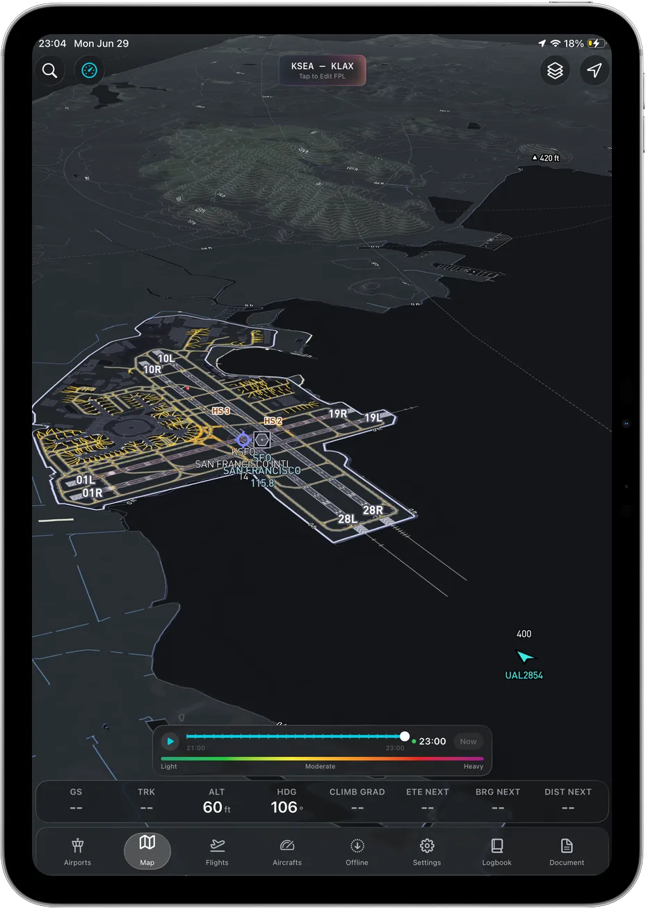
3D terrain renders the ground as ground. Ridgelines look like ridgelines, a valley looks like a valley, and the answer to "will I clear that" arrives before you finish asking. This is what we built Ascent around, and it is in the single plan because there is no other plan.
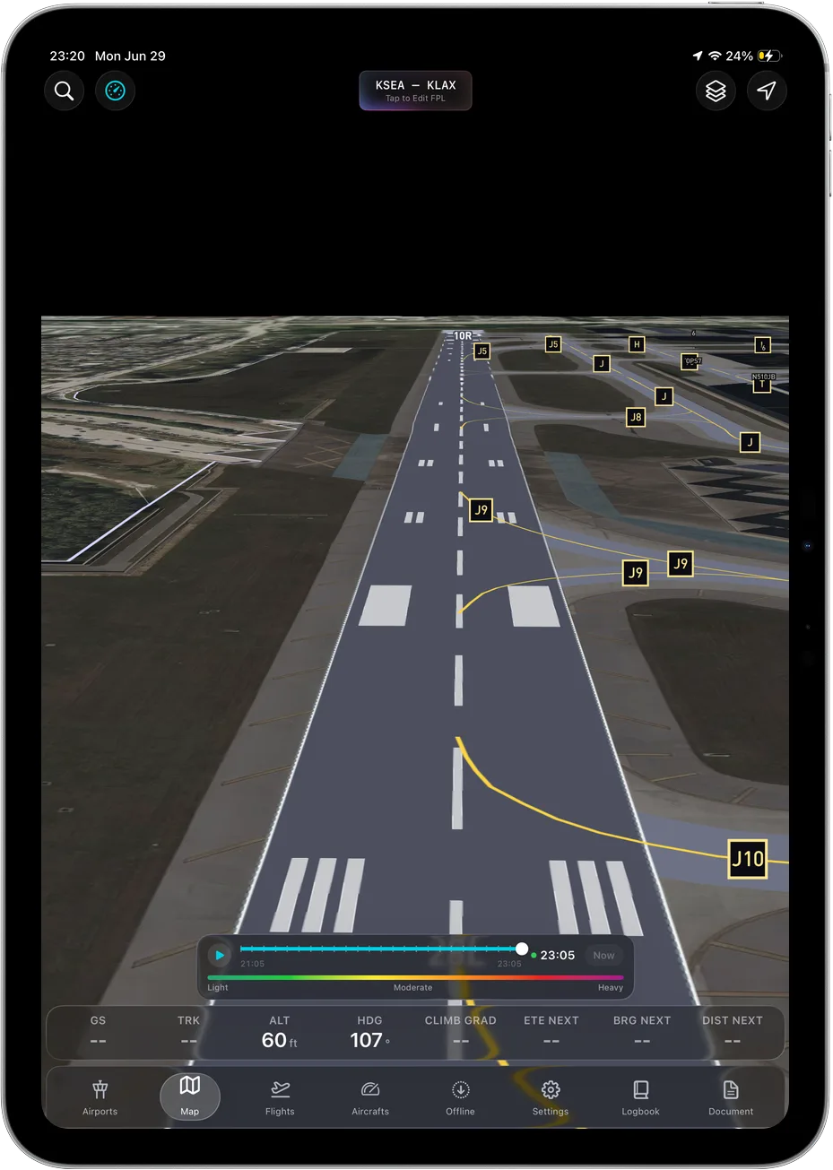 3D terrain rendered as terrain, not inferred from contour lines.
Two honest caveats. Your own aircraft in Ascent is a 2D heading-up puck on the map, not a 3D model of your airplane. The terrain is the three-dimensional part. And no terrain rendering, ours included, replaces looking out the window or a real terrain awareness and warning system.
On ForeFlight the comparable capability is Synthetic Vision, and their pricing page on August 26, 2026 lists Synthetic Vision, Hazard Advisor with Automatic Hazard Alerts, and Terrain Profile View with Airspace in the Essential and Premium tiers rather than the $130 Starter tier. So if you fly in the mountains and you are pricing ForeFlight, price Essential. Garmin Pilot publishes two US tiers, Standard at $109.99 and Premium at $209.98 as read from Garmin's own US plan catalog on August 8, 2026, and Garmin's own plan list puts synthetic vision and terrain and obstacle alerts under Premium. Check Garmin's current pages before you buy, since prices and tier contents change.
2. Winds aloft, and reading them as terrain instead of numbers
Wind is the mountain hazard people underestimate. Most mountain courses teach some version of the same rule: once the ridge-level wind is up around 20 to 25 knots, mechanical turbulence and downdrafts on the lee side stop being theoretical. Add mountain wave and rotor and a reasonable-looking VFR day becomes a bad idea in a light single.
What you want from the app is winds aloft at the altitudes you will actually fly, not just the cruise altitude you filed, plus AIRMET Tango and any SIGMET in the box. Ascent carries winds aloft with METAR, TAF, radar, AIRMET and SIGMET in the base plan. Most serious EFBs carry this too, so treat it as a checklist item rather than a differentiator: make sure you can get the winds at pass altitude, not just at 9,000 feet.
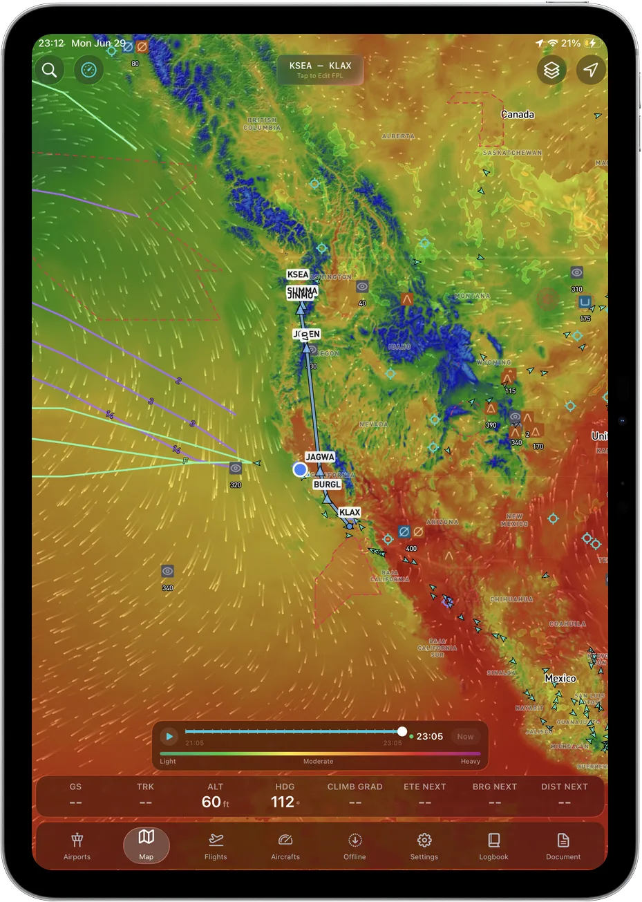 Winds at the altitude you are actually going to be at, not just the one you filed.
Then do the part no app does for you: cross the wind against the terrain. Wind perpendicular to a ridge means lift on one side and sink on the other, and you plan to cross at an angle so you can turn away instead of committing.
3. Density altitude, which is arithmetic your app will not save you from
We are not going to oversell this one. Density altitude in the mountains is a performance problem, not a display problem. A summer afternoon at a 6,000 foot strip can easily put density altitude near 9,000, and your climb rate, takeoff roll and service ceiling all move with it.
What an EFB genuinely helps with is inputs: field elevation, current temperature and altimeter from the METAR, and the winds. Ascent gives you those. The number itself, and what it does to your airplane at your weight, comes out of the POH. Run it on the ground, decide on the ground, then use the app to fly the plan you made.
4. Offline, because the valley is where the coverage ends
After terrain, this is what we would weight highest. Cell coverage in mountain country is patchy at the ramp and mostly absent in the terrain itself. Any part of your EFB that quietly depends on a live connection will not be there when it matters.
Do the check before you buy, not after. Cache your route on wifi, put the iPad in airplane mode, and see what still works. In Ascent, full offline caching covers charts, the 3D terrain and the weather you already pulled, so the map keeps drawing terrain with the device sealed off. Several established apps do offline well too. Verify it yourself rather than trusting anyone's feature table, ours included.
5. Escape routes, which are a planning habit more than a feature
No EFB has an "escape route" button worth trusting, so this is technique the app supports rather than performs.
- Mark the low terrain before you go: valleys that stay wide, passes with an alternate on the far side, and airports you can reach from cruise with the engine at idle.
- Plan crossing altitude with real margin above the pass, then check it against the density altitude you already worked out.
- Know your turn-around point in every canyon before you enter it, and fly one side rather than the middle so you have room to turn.
- Get the weather for the far side of the ridge, not just where you are. The trap is that it looks fine from here.
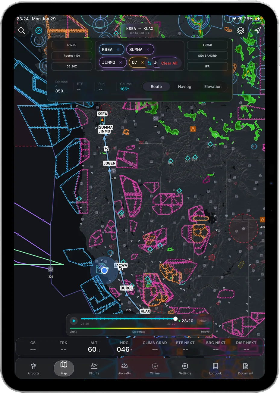 Route, airspace and terrain on one map, so the escape options are visible while you fly.
The app's job is to make those decisions fast to see and hard to forget, which is why terrain rendering and offline reliability matter more here than almost anything else on a spec sheet.
The part the feature table cannot tell you
Every app in the table above has a terrain row. If you chose on rows you would flip a coin, and then you would find out in a canyon whether you chose well.
The useful comparison is not how many terrain capabilities an app lists. It is how fast the app answers a question you asked with one hand on the yoke. That is a design property, and design properties do not fit in table cells.
The closest analogy is flight tracking. A web flight tracker and Flighty technically show you the same flight, off the same data. Nobody who has used both has ever thought they were the same product. What changed was not the dataset, it was how many seconds and how much attention it costs you to get the answer out.
Most EFBs were architected a long time ago, and it shows the moment you open one: density tuned for a planning room, layers buried behind taps, terrain as a thing you switch on rather than a picture you fly with. We are not going to claim we have more mountain features than ForeFlight, because we do not. We are claiming that terrain is the one place where the design difference is visible in about four seconds, and that four seconds is worth more to you in a canyon than a longer feature list is.
Go look at it rather than trusting anyone's table, ours very much included.
The three apps, same four headings each
Ascent EFB
Key features. 3D terrain rendered as ground rather than as color bands, in the only plan there is. Geo-referenced FAA VFR Sectionals and Terminal Area Charts. IFR Enroute Low, High and Area charts. Full weather stack: METAR, TAF, radar, winds aloft, AIRMET and SIGMET. Live traffic. Airport information and taxi diagrams. Full offline caching of charts, terrain, airport data and the last weather you pulled, so the picture survives a valley with no bars. Own-ship is a 2D heading-up puck. iPhone and iPadOS only.
Who it suits. GA pilots flying single-pilot in terrain who want the shape of the ground rather than an elevation number, and who do not want to work out which tier holds the terrain layer. Pilots who cache regions and fly with the tablet effectively offline.
Pricing. $59.99 the first year, then $89.99 a year. One plan, everything in it, no tiers and no add-ons.
Sourced note. Ours, so the useful half is what is missing: no terrain alerting of any kind, no geo-referenced approach charts, no weight and balance, no Android, and a August 2026 launch rather than a decade of accumulated depth.
ForeFlight
Key features. Per foreflight.com/pricing, read August 26, 2026: Synthetic Vision, Hazard Advisor with Automatic Hazard Alerts and Terrain Profile View with Airspace sit in the Essential and Premium tiers. 3D Review sits in Premium only. Geo-Referenced Approaches and Charts sit in Essential and above. Pilot Logbook is on all three tiers.
Who it suits. Mountain pilots who want an automatic alerting layer on top of the terrain picture, and instrument pilots who want own-ship on the approach chart.
Pricing. $130 Starter, $260 Essential, $390 Premium per year, read from foreflight.com/pricing on August 26, 2026.
Sourced note. All of the above is from ForeFlight's own published pricing page on that date. The practical implication from that same page: if terrain is why you are buying, the $130 Starter number is not your real price.
Garmin Pilot
Key features. Garmin's own published US plan catalog, read August 8, 2026, lists two US tiers and puts synthetic vision and terrain and obstacle alerts under Premium. Garmin publishes Garmin Pilot on Google Play under the Garmin developer account, checked August 26, 2026, so Android is covered as well as iOS.
Who it suits. Pilots flying Android tablets, and pilots with Garmin avionics in the panel.
Pricing. $109.99 US Standard and $209.98 US Premium, read from Garmin's own published US plan catalog on August 8, 2026.
Sourced note. From Garmin's own pages on the dates given. Garmin runs promotions that move the effective price, so read the live catalog rather than this paragraph.
Where ForeFlight still wins
Specifically, and in the mountains, which is the only place this post is entitled to an opinion.
Automatic terrain alerting. ForeFlight's own pricing page, read August 26, 2026, lists Hazard Advisor with Automatic Hazard Alerts in Essential and Premium. Ascent shows you terrain. It does not watch it for you and it will not interrupt you. In a canyon, at night, tired, an app that speaks up is a different category of help, and ForeFlight publishes that capability and we do not.
Terrain Profile View with Airspace, Essential and above on the same page, is a vertical slice along the route with airspace drawn on it. For pass crossings that is a genuinely good way to look at the problem and we have no equivalent.
3D Review, Premium only on that page, replays the flight in three dimensions afterwards. Debriefing a mountain leg that way is one of the better learning tools in GA and we do not offer it.
Where Garmin Pilot still wins
Garmin's own published US plan catalog, read August 8, 2026, puts terrain and obstacle alerts under the Premium tier, which is again an alerting capability we do not have. And Garmin publishes Garmin Pilot on Google Play, checked August 26, 2026. If your cockpit tablet is Android, Ascent is not an option for you at all and Garmin is the serious answer.
How we checked this, and our bias
We are biased. Ascent EFB is our app, we would like you to buy it, and this post recommends the feature we built the company around.
So the rule is: every claim about somebody else's product here comes from that vendor's own published page with the date we read it, and you can open the same page and check us. ForeFlight plan names, prices and tier contents were read from foreflight.com/pricing on August 26, 2026. Garmin Pilot US plan names, prices and tier contents came from Garmin's own published US plan catalog on August 8, 2026, and Android availability from Garmin's listing on Google Play on August 26, 2026. We do not run comparative bench tests of competitor apps, and if we cannot point you at a source for a limitation, we cut the sentence instead of hedging it.
The short version
Ascent EFB comes out strong on two things here, on ground we are willing to defend: 3D terrain, which the app was built around and which is in the only plan there is, and full offline caching covering charts, terrain and already-pulled weather. $59.99 the first year, $89.99 a year after, one plan, nothing held back behind a tier. It is on the App Store for iPhone and iPad: apps.apple.com/us/app/ascent-efb/id6756762115.
The trade-offs are the same ones we put in every post. Ascent launched in August 2026, so it does not have the incumbents' decade of accumulated depth. It is iPhone and iPad only, no Android app. No geo-referenced approach charts today. No terrain alerting. And own-ship is a 2D puck.
Buy something else if:
- You want the app to alert you about terrain, not just show it. ForeFlight publishes Hazard Advisor with Automatic Hazard Alerts in Essential and above, per their pricing page read August 26, 2026. Buy that.
- You fly an Android tablet. Garmin publishes Garmin Pilot on Google Play, checked August 26, 2026. We are iOS and iPadOS only and that is not changing this year.
- You fly instrument approaches into mountain airports in actual IMC and want your aircraft drawn on the approach chart. ForeFlight's page puts geo-referenced approach charts in Essential and above.
If what you want is to look at a pass and understand it immediately, with the tablet in airplane mode, that is the case we built Ascent for.
For the wider field, we compared every published plan and price in best EFB apps 2026, went head to head in Ascent EFB vs ForeFlight, broke down real annual cost in how much an EFB costs, and walked through the general decision in choosing an EFB.
Written by Vincent Wu, founder of Ascent EFB at Geospatios. ForeFlight plan names, prices and tier contents were read from foreflight.com's published pricing page on August 26, 2026. Garmin Pilot tier names, prices and tier contents come from Garmin's own published US plan catalog, read August 8, 2026, and Android availability from Garmin's listing on Google Play on August 26, 2026. All of it changes over time. Ascent EFB is our product, so treat our opinions about it as ours. Any EFB is a supplemental aid to situational awareness, and final authority rests with the pilot in command. Nothing here is mountain flying instruction: if you are new to terrain, go get a mountain checkout from an instructor who flies there.
Try Ascent EFB
Free for 30 days, then $59.99 your first year
One plan with everything in it: 3D terrain, geo-referenced FAA charts, the full weather stack and live traffic, all cached offline. $89.99 a year after the first. One trial per account, no card needed to look around.
Start a 30-day trial