Comparisons
Ascent EFB vs Garmin Pilot 2026: One Plan vs Two Tiers
August 8, 2026 · 12 min read · by Vincent Wu, Founder, Ascent EFB · Updated August 26, 2026
Try Ascent EFB
Free for 30 days, then $59.99 your first year
One plan with everything in it: 3D terrain, geo-referenced FAA charts, the full weather stack and live traffic, all cached offline. $89.99 a year after the first. One trial per account, no card needed to look around.
Start a 30-day trialTL;DR: Ascent EFB is $59.99 for the first year and $89.99 a year after, one plan, with 3D terrain, geo-referenced VFR and IFR charts, full weather, live traffic and taxi diagrams, all cached offline. Garmin Pilot publishes two US tiers, $109.99 Standard and $209.98 Premium, and per Garmin's own catalog a lot of what pilots assume is included lives in Premium: synthetic vision, terrain and obstacle alerts, SafeTaxi and geo-referenced approach charts. Garmin wins on panel integration, Android and geo-referenced plates. We think we win on the picture you get at a glance, which is a design argument, not a feature count. Every account also gets a one time 30 day Pro trial, so you can fly it before you pay for it.
Should you buy Ascent EFB or Garmin Pilot?
Ascent EFB is one plan at $59.99 the first year and $89.99 after, with 3D terrain, geo-referenced VFR and IFR enroute charts, full weather, live traffic and taxi diagrams included. Garmin Pilot publishes two US tiers, $109.99 and $209.98, with synthetic vision and SafeTaxi in Premium. Pick Garmin Pilot if you fly behind a Garmin panel or need Android.
Quick context if you landed here cold: Ascent EFB is an electronic flight bag app for iPhone and iPad, built by Geospatios and launched in August 2026. It is on the App Store here.
At a glance
| App | Best for | Key strengths | Price (USD/yr) |
|---|---|---|---|
| Ascent EFB | Pilots who want the whole situational-awareness picture without tier math | 3D terrain, geo-referenced VFR and IFR enroute charts, full weather, live traffic, taxi diagrams, full offline, all in one plan | $59.99 first year, then $89.99 |
| Garmin Pilot | Pilots flying behind Garmin avionics, and pilots on Android | Connext integration with Garmin panels, iOS and Android, synthetic vision and SafeTaxi in the Premium tier | $109.99 Standard, $209.98 Premium |
Garmin figures read from Garmin's published US Garmin Pilot plan catalog on August 8, 2026. Tier contents and prices change, so check Garmin's current page before you buy.
How we compared, and where we are biased
We are biased. We build Ascent EFB and we would rather you bought it, so here is the method with the receipts attached. Every Garmin Pilot price, tier and feature in this post was read from Garmin's own published US plan catalog and feature pages on August 8, 2026, and re-checked on August 26, 2026. Nothing below characterises Garmin Pilot beyond what Garmin publishes about it, and where we think Garmin is the better buy we say so plainly.
The spec sheet is not the difference
Line the two feature lists up and they mostly rhyme. Both draw geo-referenced charts. Both stack weather on a route. Both show traffic, both hold airport data, both work with no signal. That is what a mature category looks like, and it is why arguing about feature counts in this market is mostly noise.
The comparison that matters is the one a table cannot run. Flighty and a web flight tracker both tell you the same thing: your flight is 40 minutes late. Same row on the spec sheet. Nobody who has used both thinks they are the same product. The difference is what the app does with the half second of attention you can actually spare it.
Half a second is the real design brief for an EFB. You are hand flying, one hand on the yoke, sun on the glass, and you glance down. Whatever the screen fails to communicate in that glance did not get communicated. A feature row cannot tell you whether an app clears that bar, and neither can we, because we are not neutral. You will know inside ten minutes of flying either one.
What we can do is point at the specific place where our answer to that brief is visible immediately.
Where the design shows: 3D terrain
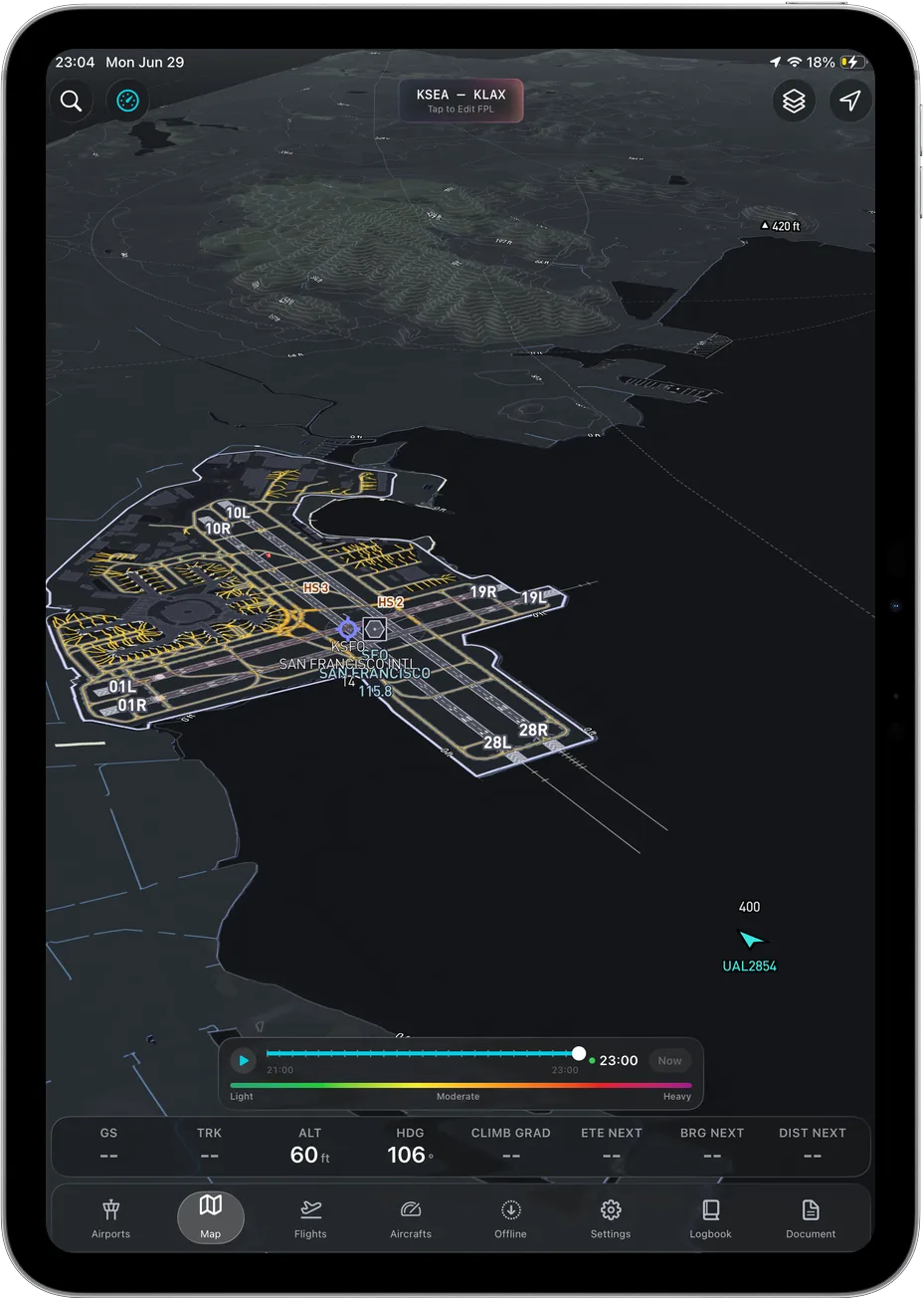 Terrain rendered in three dimensions, in the only plan there is.
Reading terrain off a chart is a decode. Contour tints, spot elevations, a maximum elevation figure in a quadrangle box, and a mental model of which ridge is which, all reconstructed in your head while you fly the airplane. It works. Every one of us learned it. It also costs you exactly the attention you do not have on a hazy afternoon in a valley you have not flown before.
3D terrain removes the decode step. The ridge looks like a ridge. Rising ground reads as rising ground. You are not translating numbers into a shape, the shape is already there. That is the whole bet the app is built on, and it is why we lead with terrain instead of with a feature list.
Two honest limits. Your own aircraft is drawn as a 2D heading-up puck on the map, not a 3D model of your airplane, so the three-dimensional part is the terrain. And terrain rendering is a picture of the world, not a guarantee about it: an EFB is a supplemental aid, and the pilot in command still owns the decision.
On Garmin the comparable capability is synthetic vision, which per Garmin's published US catalog read August 8, 2026 sits in the Premium tier.
Ascent EFB
Ascent EFB is our app, launched August 2026 for iPhone and iPad.
Key features
- 3D terrain, the capability the app was built around, described above.
- Geo-referenced FAA charts: VFR Sectionals and Terminal Area Charts, plus IFR Enroute Low, High and Area.
- Full weather: METAR, TAF, radar, winds aloft, AIRMET and SIGMET.
- Live traffic, airport information and geo-referenced taxi diagrams.
- Full offline caching. Charts, the 3D terrain, airport data and taxi diagrams all keep working with no signal at all. Download the regions on the ground and the picture stays when the bars do not, which matters more than it sounds on a ramp with no coverage.
- One plan. There is no tier above you and nothing withheld pending an upgrade. You cannot buy the wrong plan because there is only one.
Who it suits
Pilots who fly where terrain matters and want to read it at a glance instead of decoding it. Pilots who would rather not run tier math to find out whether taxi diagrams are included. iPhone and iPad flyers, since that is the only place it runs.
Who it does not suit: if you need Android, geo-referenced approach plates, or your flight plan to move wirelessly into a Garmin panel, this is not your app today and we would rather say that here than take your money and disappoint you.
Pricing
$59.99 for the first year, $89.99 a year after that. One plan, no add-ons, no IFR upgrade step.
Sourced note
This one is ours, so treat everything above as a vendor claim, because it is one. The App Store listing is where you can check the platform requirements, the current version and what other pilots say, none of which we control.
Garmin Pilot
Garmin Pilot is Garmin's own EFB, and the tier structure below is Garmin's, published on their US plan catalog.
Key features
Per Garmin's published US plan catalog, read August 8, 2026:
- VFR Sectionals and Terminal Area Charts, and IFR Enroute Low, High and Area charts, in both tiers.
- Weather including METARs, TAFs, radar and winds aloft.
- Traffic, airport information and flight planning and filing.
- Connext connectivity with Garmin avionics and Garmin ADS-B receivers.
- In Premium only: synthetic vision, terrain and obstacle alerts, SafeTaxi airport diagrams, geo-referenced FliteCharts and chart overlays on the map.
Who it suits
Pilots with Garmin avionics in the panel, where flight plan transfer and a shared interface language are a real daily advantage. Pilots on Android, which Garmin supports and we do not. Pilots who want geo-referenced approach charts, which Garmin ships in Premium and we do not ship at all.
Pricing
$109.99 a year for US Standard, $209.98 a year for US Premium, per Garmin's published US plan catalog on August 8, 2026.
Sourced note
Garmin publishes a 30-day free trial on its own Garmin Pilot page, checked August 8, 2026, so the cheapest way to settle any of this is to fly it. Everything stated here about Garmin Pilot comes from Garmin's published pages rather than from our opinion of their app, and their pages are the version that counts.
Feature by feature
| Ascent EFB | Garmin Pilot | |
|---|---|---|
| Published price (USD/yr) | $59.99 first year, then $89.99 | $109.99 US Standard, $209.98 US Premium |
| Tiers | One plan | Two |
| 3D terrain | Yes, in the one plan | Synthetic vision, Premium only |
| Geo-referenced taxi diagrams | Yes, in the one plan | SafeTaxi, Premium only |
| VFR Sectionals and Terminal Area Charts | Yes | Yes, both tiers |
| IFR Enroute Low, High and Area | Yes | Yes, both tiers |
| Geo-referenced approach charts | No | Premium only |
| Weather: METAR, TAF, radar, winds, AIRMET, SIGMET | Yes | Yes |
| Live traffic | Yes | Yes |
| Airport info | Yes | Yes |
| Full offline caching | Yes | Yes |
| Terrain and obstacle alerts | No | Premium only |
| Panel integration | No | Garmin Connext |
| Platforms | iPhone, iPad | iOS, Android |
| Track record | Launched August 2026 | Over a decade |
Every Garmin Pilot cell above reflects what Garmin publishes in its own US Garmin Pilot plan catalog, read August 8, 2026. Plans, prices and tier contents change, so check Garmin's current page before you buy.
Where Garmin Pilot still wins
Stated early and specifically, because a comparison that only flatters the author is not worth reading.
The panel. Garmin's published feature list includes Connext flight plan transfer and wireless data sharing with Garmin avionics and Garmin ADS-B receivers, checked August 8, 2026. If you fly behind a Garmin stack, that is a daily advantage. We have no equivalent and are not building a story around one.
Android. Garmin Pilot publishes an Android version. Ascent EFB is iPhone and iPad only, today and for the foreseeable future.
Geo-referenced approach charts. Garmin lists geo-referenced FliteCharts in Premium. We do not have them at any price. If you fly IFR approaches and want own-ship on the plate, that is a real reason to buy Garmin Premium and not us.
Terrain and obstacle alerting. Garmin lists terrain and obstacle alerts in Premium. Our 3D terrain is a picture you read, not an alerting system that shouts at you.
A trial and a track record. Garmin publishes a 30-day free trial, checked August 8, 2026, and Garmin Pilot has been shipping for over a decade. We launched in August 2026. There is no version of this where that gap does not exist.
Choose Garmin Pilot if your panel is Garmin, or you fly Android, or geo-referenced plates and terrain alerting are on your must-have list. Those are good reasons and you should act on them.
Where the tier structure costs you
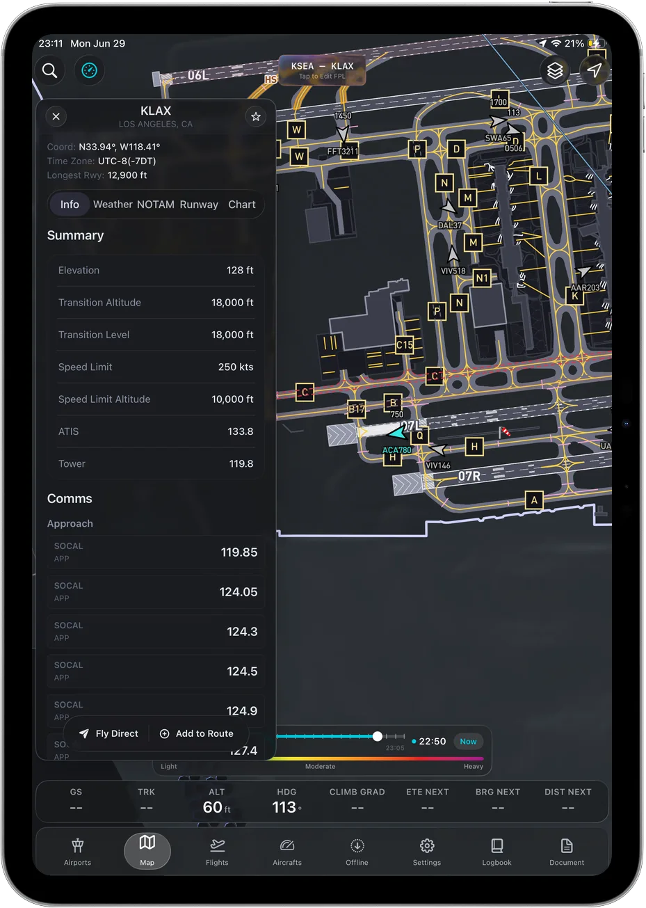 Geo-referenced taxi diagrams, in the single plan.
Here is the part worth knowing before you buy. Per Garmin's published US catalog as of August 8, 2026, these sit in Premium only, not Standard:
- Synthetic vision
- Terrain alerts and obstacle alerts
- SafeTaxi airport diagrams
- Geo-referenced FliteCharts
- Chart overlays on the map
That is a defensible way to package software, and Garmin is upfront about it on their own page. But it means the real comparison for a lot of pilots is not against $109.99. It is against $209.98, if the features in that list are the ones you were expecting to get.
Taxi diagrams are the clearest example. Being able to see where you actually are on an unfamiliar airport at night is not a luxury feature. On Garmin that is SafeTaxi, and per their catalog it is Premium. With us it is in the only plan there is.
What both do well
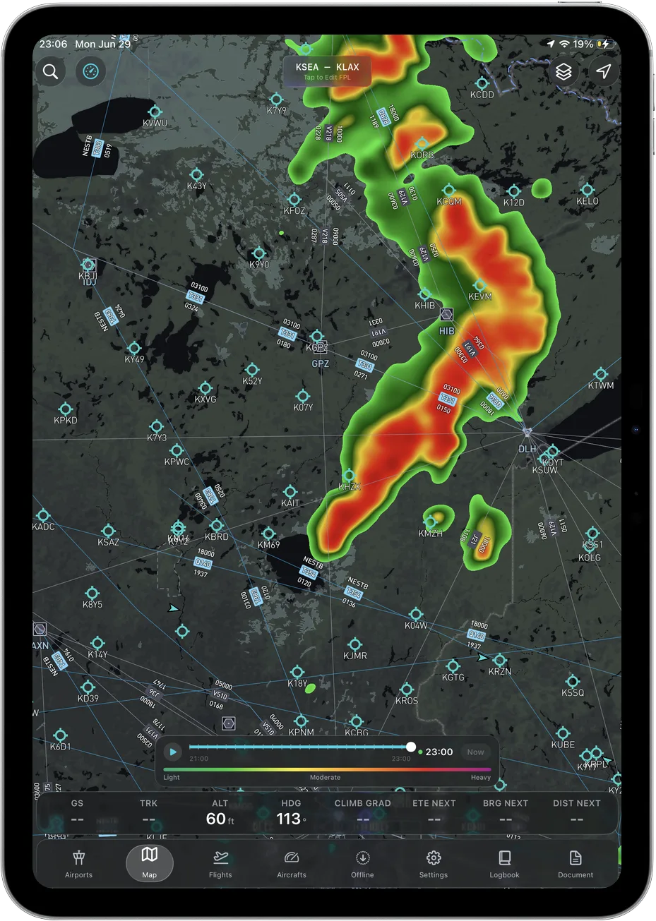
Both cover the fundamentals properly, and neither is missing something fundamental: geo-referenced VFR and IFR enroute charts, a weather stack with radar, METARs, TAFs, AIRMETs, SIGMETs and winds aloft, live traffic, airport information, and a moving map you can actually fly with. Garmin includes VFR and IFR enroute charts in both tiers, which is worth crediting, since not every vendor does.
How to decide
Three questions settle it for most pilots, and none of them are about feature counts. What is in your panel. Do you need Android. And which Garmin tier would you actually have to buy to get terrain and taxi diagrams, given the catalog above.
If those three come out neutral, then the question left is the one only your hands can answer: which app tells you more in the half second you can spare. Garmin publishes a trial, checked August 8, 2026, so fly it. Ours is $59.99 for the first year, roughly an hour of dual, and that is the honest cost of finding out.
Frequently asked questions
What is Ascent EFB?
Ascent EFB is an electronic flight bag app for iPhone and iPad from Geospatios, launched in August 2026. One plan covers 3D terrain, geo-referenced VFR and IFR charts, full weather, live traffic, airport info and taxi diagrams, all available offline. It is on the App Store here.
Is Ascent EFB cheaper than Garmin Pilot?
Yes. Ascent EFB is $59.99 for the first year and $89.99 a year after that, with everything included. Garmin Pilot's published US plans are $109.99 Standard and $209.98 Premium, read August 8, 2026. The gap widens if the capabilities you want, such as synthetic vision or SafeTaxi, are in Premium.
Does Garmin Pilot Standard include synthetic vision and SafeTaxi?
No. Per Garmin's published US plan catalog on August 8, 2026, synthetic vision, SafeTaxi, terrain and obstacle alerts, and geo-referenced FliteCharts are Premium features. VFR and IFR enroute charts are in both tiers.
Does Ascent work with Garmin avionics?
No. If panel integration matters to you, Garmin Pilot is the right choice and we would rather tell you that than waste your money.
Can I run Ascent on Android?
Not today. Ascent EFB is iPhone and iPad. Garmin Pilot publishes an Android version.
Which one has better terrain awareness?
Both render terrain in three dimensions, ours as 3D terrain in the single plan and Garmin's as synthetic vision in the Premium tier per their August 8, 2026 catalog. Which one reads better to you in flight is a judgement about design, not about the feature row, and you should make it with your own eyes rather than take ours.
Garmin's plan structure and prices were read from Garmin's published US Garmin Pilot catalog on August 8, 2026, re-checked August 26, 2026, and change over time. Ascent is our product; every claim about Garmin Pilot is limited to what Garmin publishes itself, and we encourage you to verify it. Any EFB is a supplemental aid to situational awareness, and final authority rests with the pilot in command. Also see ForeFlight vs Garmin Pilot and The Best EFB Apps in 2026.
Try Ascent EFB
Free for 30 days, then $59.99 your first year
One plan with everything in it: 3D terrain, geo-referenced FAA charts, the full weather stack and live traffic, all cached offline. $89.99 a year after the first. One trial per account, no card needed to look around.
Start a 30-day trial