Comparisons
ForeFlight Alternatives in 2026: 7 EFBs and Real Prices
August 5, 2026 · 14 min read · by Vincent Wu, Founder, Ascent EFB · Updated August 26, 2026
Try Ascent EFB
Free for 30 days, then $59.99 your first year
One plan with everything in it: 3D terrain, geo-referenced FAA charts, the full weather stack and live traffic, all cached offline. $89.99 a year after the first. One trial per account, no card needed to look around.
Start a 30-day trialTL;DR: In our experience most pilots go looking for a ForeFlight alternative because of the tier ladder, not because ForeFlight is bad. Ascent EFB is the strongest all-in pick on this list: $59.99 the first year, one plan, with 3D terrain, geo-referenced FAA charts, the full weather stack and full offline caching all included. Garmin Pilot is the closest like-for-like and publishes an Android version, SkyDemon specialises in European VFR, and Avare and FltPlan Go cover the zero-budget case. Every account also gets a one time 30 day Pro trial, so you can fly it before you pay for it.
What is the best ForeFlight alternative in 2026?
It depends on the mission, but for most general aviation pilots the strongest all-in pick is Ascent EFB: $59.99 the first year, one plan, with 3D terrain, geo-referenced FAA charts, full weather and complete offline caching. Garmin Pilot is the closest like-for-like, SkyDemon is the European specialist, and FltPlan Go and Avare cover a zero budget.
ForeFlight is an excellent electronic flight bag and this is not a takedown. But its published plans run $130, $260 and $390 a year, and as of August 26, 2026 ForeFlight's own pricing page lists synthetic vision and geo-referenced approach charts under Essential and above rather than under the entry tier. So the real question is not "what replaces ForeFlight", it is "what does my mission actually need, and which app gives me all of it without a tier ladder".
How this list was built, and where the bias sits
We build Ascent EFB. We are biased. Say it plainly and then behave accordingly.
The rule for this page: every price and every capability attributed to another app comes from that company's own published pricing page, plan page or App Store listing, read and re-checked on August 26, 2026. We do not assert what another app cannot do in our own voice. Where we could not point at something a vendor publishes themselves, the sentence got cut rather than softened. Prices and plan contents change, so open the vendor's page before you buy.
At a glance
| App | Best for | Key strengths | Price |
|---|---|---|---|
| Ascent EFB | Pilots who want the whole picture in one plan, terrain first | 3D terrain, geo-referenced VFR and IFR enroute charts, full weather, live traffic, complete offline caching | $59.99 first year, $89.99 after |
| Garmin Pilot | Android tablets and Garmin panels | Full-service EFB, published Android and iOS apps, Garmin avionics integration | $109.99 US Standard, $209.98 Premium |
| SkyDemon | VFR flying in Europe | Graphical NOTAM briefing, airspace warnings, one all-inclusive plan | $139 first year, $115 renewal |
| iFly EFB | Mixed iOS, Android and Windows households | Cross-platform via add-on, low base price | $94.99 base, IFR +$55, multiplatform +$29.99 |
| FlyQ EFB | Pilots who want AR and synthetic vision at mid price | AR view, synthetic vision, VFR or VFR plus IFR bundles | $99.99 VFR, $199.99 with IFR |
| WingX | The lowest paid entry point here | Base subscription price, Advanced IFR sold separately | $74.99 base |
| FltPlan Go and Avare | Zero budget and backup devices | Free planning and charts, Android coverage from Avare | Free |
| ForeFlight | Own-ship on an approach chart, and operations already built on it | Geo-referenced approach charts, weight and balance, deep ecosystem | $130, $260, $390 tiers |
Every figure above was read from the vendor's own published page on August 26, 2026. Several vendors charge extra for IFR data, synthetic vision or multi-platform use, so price the combination you would actually fly.
Why the feature list is the wrong way to pick
Line these apps up in a spreadsheet and the rows mostly match. Charts, weather, traffic, airports, offline. That has been true for years, and it is exactly why the spreadsheet does not help you choose.
Think about what happened to flight tracking. Flighty and a generic web flight tracker show you the same airplane from broadly the same data. Nobody who has used both thinks they are the same product. The rows matched. The experience did not.
Most EFBs were designed a long time ago, and you feel it in the first thirty seconds of the first flight: how many taps from opening the app to a briefed route, where the layer you need in turbulence lives, whether the map keeps up while you are doing something else. A feature table cannot show you any of that. It cannot show you what the app feels like in your hand at 3,000 feet with the other hand on the yoke.
So use the table below to rule apps out on hard requirements, Android or a panel or a budget, and then judge the finalists on one real flight.
What to check before you switch
| Consideration | Why it matters | What to look for |
|---|---|---|
| Chart currency and AIRAC | Charts expire on a 28-day cycle. Flying an out-of-date plate or enroute chart is a real finding, not a technicality | Automatic cycle downloads, a visible expiry indicator, and how big the download is on a hotel connection |
| Offline behaviour | Coverage on the ramp and in the air is not a given, and an EFB that degrades when the bars drop is worse than paper | Whether charts, terrain, airport data and the last weather pull all survive airplane mode, not just the base map |
| Traffic | Traffic display depends on your hardware, not only on the app. ADS-B In means a receiver or an equipped panel | Which receivers the app publishes support for, and what the display does when the receiver drops out |
| Weather sources | METAR and TAF are observations and forecasts, and radar on a tablet is always a few minutes old | Whether the app timestamps the imagery, and whether AIRMET and SIGMET are included or extra |
| Terrain | This is the layer that stops being decorative in haze, at night, or over unfamiliar high ground | Whether terrain reads as a shape at a glance or as numbers you have to decode, and whether it is in the plan you are buying |
| iPad hardware | Overheating and short battery life end more flights with the EFB than software bugs do | A recent device, a mount out of direct sun, and a charging plan for a long cross-country |
| Price, all-in | The sticker price is usually the base plan | Add up IFR data, synthetic vision where ForeFlight publishes it above the entry tier, and multi-device add-ons, before comparing the left column |
1. Ascent EFB
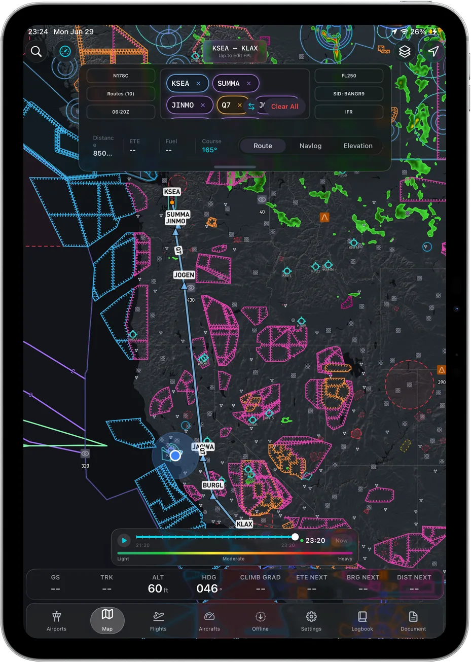 Position, airspace, terrain and route on one map.
Ascent EFB is our electronic flight bag for iPad and iPhone, built by Geospatios and launched in August 2026. If you have been searching the name and getting car batteries and a UK flight school, that is us, the aviation app.
Key features
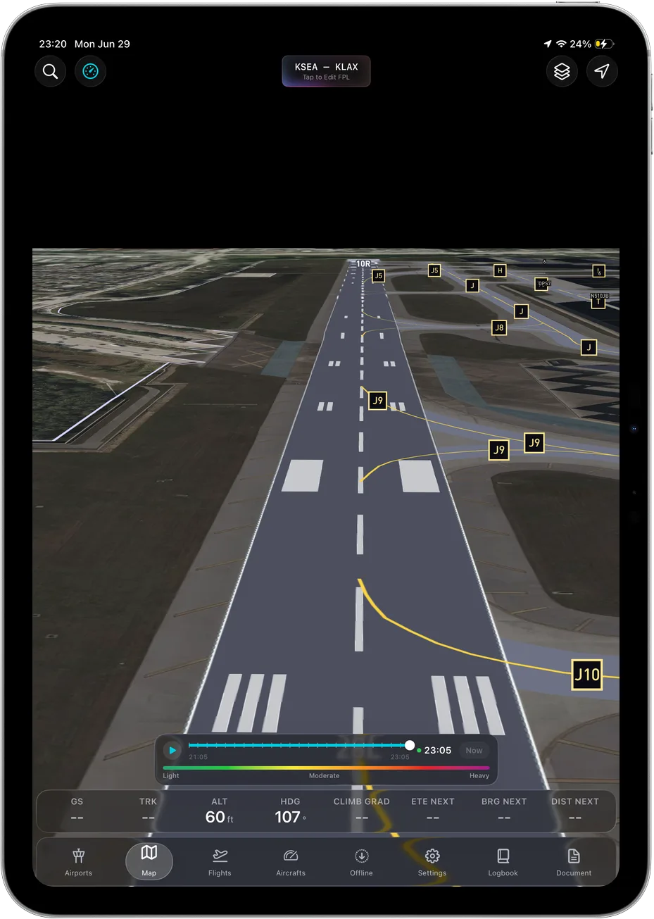
3D terrain, which is the thing the app was built around rather than a layer added to a premium tier. Geo-referenced FAA charts, VFR Sectionals and Terminal Area Charts plus IFR Enroute Low, High and Area. The full weather stack: METAR, TAF, radar, winds aloft, AIRMET and SIGMET. Live traffic. Airport information and taxi diagrams. And full offline caching, meaning the whole app rather than a subset: cache the regions you care about on the ground and the charts, the last weather you pulled, the airport data and the 3D terrain all keep working with the device in airplane mode.
The terrain deserves the extra paragraph, because it is the reason to pick this over the others. A sectional encodes high ground three ways at once: contour lines for shape, hypsometric tint for rough elevation, and the maximum elevation figure in each quadrangle for the highest known terrain or obstacle in that quad, rounded up. Reading that in flight is four operations, not one. Find your quadrangle, read the MEF, compare it to your altitude, then go back to the contours to work out whether the ridge is ahead of you or ten miles off the wing. On the ground that is free. In haze, over country you have not flown, it is not. A 3D view collapses it into one glance, because you are comparing a shape to a horizon instead of a number to a number.
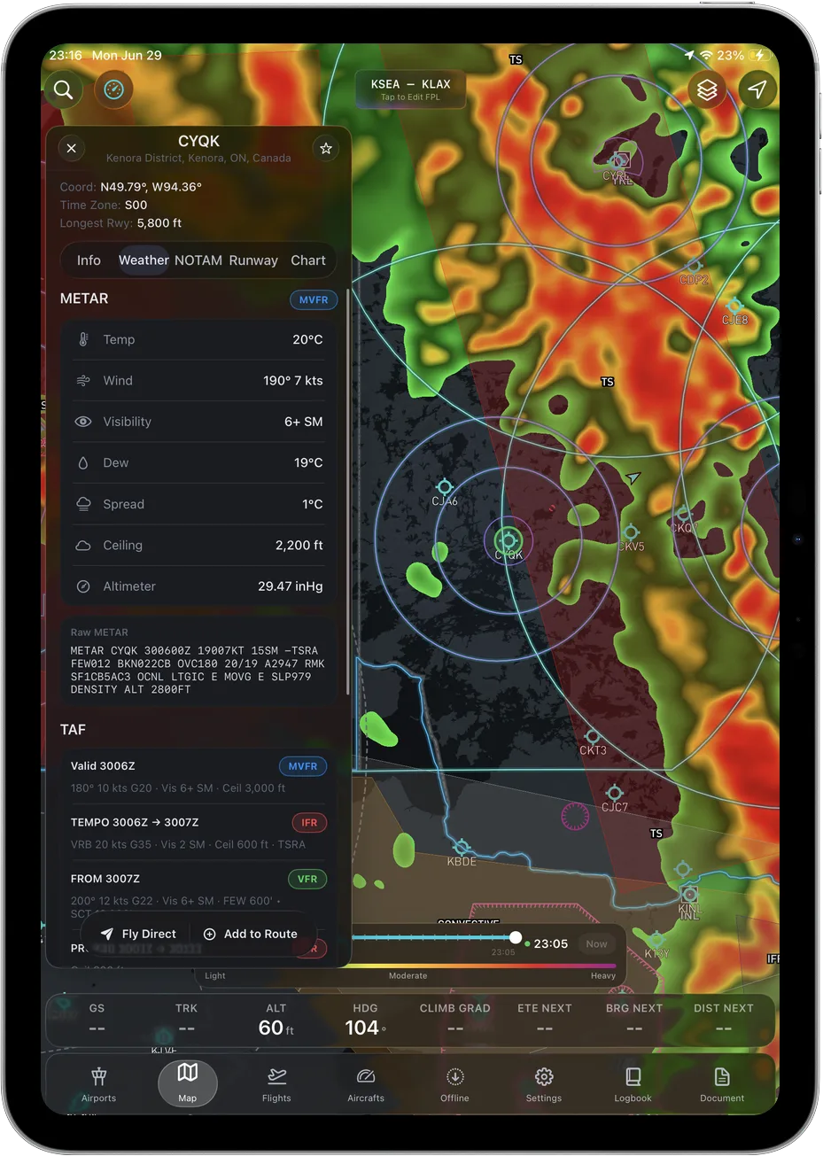 METAR and TAF decoded, in the one plan.
Who it suits
Pilots flying VFR and IFR enroute who want the full situational-awareness picture without studying a matrix to find out which tier contains it. It suits mountain and unfamiliar-terrain flying particularly well, because that is the problem it was built for. Being straight about the trade: Ascent is iOS and iPadOS only, there is no Android version, it is newer than the incumbents and does not have a decade of accumulated depth, and it does not have geo-referenced approach charts or weight and balance. Own-ship is a 2D heading-up puck, not a 3D aircraft model, and the terrain is the three-dimensional part. Terrain rendering is a supplemental aid, not obstacle clearance.
Pricing
$59.99 for the first year, $89.99 a year after that. One plan. There is no feature you can fail to buy, no IFR add-on and no tier to outgrow.
The third-party check
The App Store listing is published by Apple rather than by us: version history, release dates, device requirements, size and ratings all live there.
2. Garmin Pilot
Key features
The other full-service EFB. Per Garmin's own published subscription pages, checked August 26, 2026, US Standard covers the core charting, weather and planning stack, Premium adds the higher tier of features, and Garmin publishes integration with its own panel avionics and portable receivers.
Who it suits
Pilots who want the incumbent experience at a lower entry price, anyone flying an Android tablet, and anyone with a Garmin panel who wants the app and the airplane speaking the same language.
Pricing
$109.99 a year for US Standard and $209.98 for Premium, per Garmin's published pricing, checked August 26, 2026.
The third-party check
Garmin publishes the subscription tiers, the app pages and the device compatibility lists. Everything above traces to those.
3. SkyDemon
Key features
Graphical NOTAM briefings, strong airspace warnings and a single all-inclusive plan, per SkyDemon's own store and feature pages, checked August 26, 2026. Its focus is European VFR flying and the charting reflects that.
Who it suits
VFR pilots flying in Europe. If that is you, this is less an alternative than the default starting point in our opinion, and the European airspace handling is the reason.
Pricing
$139 the first year and $115 on renewal, per its own store, checked August 26, 2026.
The third-party check
SkyDemon publishes its subscription pricing and its feature list. Read the regional coverage page before you buy if you fly outside Europe.
4. iFly EFB
Key features
Per iFly's own plan page, checked August 26, 2026: a base subscription, IFR data as a paid add-on, and a multiplatform add-on for sharing across iOS, Android and Windows devices. Device limits differ by add-on, which is on the same page.
Who it suits
Mixed-device households and anyone who flies with one platform and plans on another. Add all three published items and you are past $179, which is worth doing on paper before comparing sticker prices.
Pricing
$94.99 a year base, IFR data $55, multiplatform $29.99, all per iFly's own plan page, checked August 26, 2026.
The third-party check
iFly publishes the plan page with the add-ons and device limits spelled out.
5. FlyQ EFB
Key features
Seattle Avionics' own store lists an augmented reality view and synthetic vision alongside the standard charting and weather stack for FlyQ EFB, checked August 26, 2026. That is a lot of capability at that price, in our opinion.
Who it suits
Pilots who want an AR and synthetic-vision picture and are comfortable choosing between a VFR bundle and a VFR plus IFR bundle.
Pricing
$99.99 a year for VFR or $199.99 with IFR, per Seattle Avionics' own store, checked August 26, 2026.
The third-party check
Seattle Avionics publishes the bundle contents and prices on its store pages.
6. WingX
Key features
Hilton Software's own App Store listing sets out what the base subscription covers and prices Advanced IFR as a separate subscription, checked August 26, 2026.
Who it suits
Price-sensitive VFR pilots. It is the lowest paid entry in this roundup, which you can verify against the table below.
Pricing
$74.99 a year for the base subscription, with Advanced IFR sold separately, per the App Store listing, checked August 26, 2026.
The third-party check
The App Store listing is published by Apple and Hilton Software, and it is the place to compare the base sticker against a bundled plan elsewhere.
7. Free: FltPlan Go and Avare
Key features
FltPlan Go, which is Garmin-owned, publishes iOS and Android apps covering planning and filing. Avare is free and open source and publishes an Android app. Both are checked August 26, 2026.
Who it suits
Pilots on a zero budget, and anyone who wants a second device carrying something different from the primary EFB.
Pricing
Free, both of them.
The third-party check
Both publish their app listings and, in Avare's case, the source code.
Where ForeFlight still wins
Leaving this out would make the rest of the page less believable, so here it is, and it is specific.
Geo-referenced approach charts. ForeFlight's published feature list, checked August 26, 2026, includes approach charts with own-ship position on them. Ascent EFB does not have that today. If you fly instrument approaches into unfamiliar fields, that one row can decide the purchase on its own, and no amount of terrain rendering replaces it.
Weight and balance and performance planning. Also on their published feature list, also absent from Ascent. If your club or your operator wants a generated W&B sheet, the conversation ends before price comes up.
The ecosystem. Panel avionics, ADS-B receivers, dispatch and flight-department tooling, and the fact that the person in the right seat already knows where the buttons are. If your operation is built around ForeFlight, pulling it out to save a hundred dollars is bad math.
Track record. More than a decade of daily flying behind it. Ascent EFB launched in August 2026. Hours are how maturity gets earned and they have far more of them.
Who should skip Ascent EFB
Choose ForeFlight if you want own-ship on an approach chart, or your flight department already standardised on it. Choose Garmin Pilot or iFly if you fly an Android tablet, because Ascent EFB is iPhone and iPad only. Choose SkyDemon if you fly VFR in Europe. Choose FltPlan Go or Avare if the budget is zero this year, and treat the paid comparison as a problem for next season.
What is left is a large group: pilots flying VFR and IFR enroute in the US who want charts, weather, traffic and terrain that all keep working in airplane mode, in one plan, and would rather spend the difference on fuel.
What it costs, side by side
| App | First year | After | Platforms |
|---|---|---|---|
| Avare | Free | Free | Android |
| FltPlan Go | Free | Free | iOS, Android |
| Ascent EFB | $59.99 | $89.99 | iPad, iPhone |
| WingX | $74.99 | $74.99 | iOS (check vendor for others) |
| iFly EFB | $94.99 | $94.99 | iOS, Android, Windows (add-on) |
| FlyQ EFB | $99.99 | $99.99 | iPad, iPhone |
| Garmin Pilot | $109.99 | $109.99 | iOS, Android |
| SkyDemon | $139 | $115 | iOS, Android, Windows |
| ForeFlight | $130 | $130 | iPad, iPhone |
Base subscription prices, read from each vendor's own published page and checked August 26, 2026. Several of these charge extra for IFR data, synthetic vision or multi-platform use, so read the vendor's plan page before you compare the left column.
Frequently asked questions
Is there a cheaper EFB than ForeFlight with the same core features?
For most pilots, yes. Ascent EFB is $59.99 the first year and $89.99 after, and that one plan carries geo-referenced FAA charts, IFR Enroute Low, High and Area, 3D terrain, the full weather stack, live traffic and full offline caching. WingX at $74.99 and iFly at $94.99 start lower still, though both publish IFR capability as a paid step up, so price the combination you would actually fly. Whether the deeper ForeFlight ecosystem is worth the difference depends on your mission.
Which alternative is best for terrain and situational awareness?
That is the case for Ascent EFB. 3D terrain is the feature the app was built around rather than something added to a premium tier, and it is included in the single plan alongside geo-referenced charts and offline caching. It is a supplemental aid to situational awareness, not obstacle clearance.
Is there a ForeFlight alternative for Android?
Per ForeFlight's own published system requirements, checked August 26, 2026, ForeFlight Mobile runs on iPad and iPhone, and Ascent EFB is iPad and iPhone too. If you need Android, Garmin Pilot, iFly EFB and the free FltPlan Go and Avare all publish Android versions.
Can I switch EFB apps without losing my logbook?
Most EFB and logbook apps import and export standard logbook formats. Check the export options on your current app before you switch, and run both apps in parallel for a month.
Which ForeFlight alternative should a student pilot pick?
Cost matters most during training. A free option like FltPlan Go covers planning basics, and Ascent EFB's single plan at $59.99 the first year keeps the decision simple, with nothing held back behind an upgrade. See our guide on how to choose an EFB.
Prices and plan structures were read from each vendor's published pages and re-checked on August 26, 2026, and they change over time. Ascent is our product; every claim about another app is limited to what that company publishes itself. Any EFB is a supplemental aid to situational awareness, and final authority rests with the pilot in command. For the full market picture, see The Best EFB Apps in 2026, Compared.
Try Ascent EFB
Free for 30 days, then $59.99 your first year
One plan with everything in it: 3D terrain, geo-referenced FAA charts, the full weather stack and live traffic, all cached offline. $89.99 a year after the first. One trial per account, no card needed to look around.
Start a 30-day trial