Comparisons
Best EFB for Student Pilots in 2026 (Prices Compared)
August 8, 2026 · 13 min read · by Vincent Wu, Founder, Ascent EFB · Updated August 26, 2026
Try Ascent EFB
Free for 30 days, then $59.99 your first year
One plan with everything in it: 3D terrain, geo-referenced FAA charts, the full weather stack and live traffic, all cached offline. $89.99 a year after the first. One trial per account, no card needed to look around.
Start a 30-day trialTL;DR: As a student you need a moving map you trust, current geo-referenced charts, weather you can read fast, terrain awareness, and everything working with no signal. You do not need most of what the expensive tiers sell. Free options exist and are genuinely usable. Among paid apps the first year runs from about $60 to $390, and our pick is Ascent EFB at $59.99 the first year because the whole feature set, 3D terrain included, comes in one plan with nothing held back. Every account also gets a one time 30 day Pro trial, so you can fly it before you pay for it.
What is the best EFB for a student pilot in 2026?
For primary training you need a moving map, current geo-referenced charts, readable weather, terrain awareness and full offline use. Free apps like FltPlan Go cover early lessons. Among paid apps, Ascent EFB is the cheapest full set at $59.99 the first year and $89.99 after, with 3D terrain included.
By Vincent Wu, founder of Ascent EFB. Updated August 26, 2026.
How we compared, and our bias
We are biased. We build Ascent EFB, an electronic flight bag for iPad and iPhone made by Geospatios, so read the Ascent block below as vendor copy and the rest as reporting. (If you searched the name and hit car batteries or a UK flight school, this is the aviation one.)
The method: every price and every statement about another app comes from that vendor's own published pricing page, product listing or support documentation, with the date it was read. Every price below was re-checked on August 26, 2026, except Garmin, checked August 8, 2026. Where we could not source a claim about a competitor, we cut it rather than soften it. We have not paid for and flown every rival tier, so we do not grade how those apps handle in the cockpit, only what their makers publish.
Every student gets the same advice: "just get ForeFlight." It is a good app. Its published plans also run $130, $260 and $390 a year, and ForeFlight's own pricing page lists Synthetic Vision, Geo-Referenced Approach Charts and Hazard Advisor under Essential and above rather than under the entry tier (foreflight.com/pricing, checked August 26, 2026). Here is what actually matters while you are training, and what the options cost.
What a student actually needs
A moving map you trust. Where you are, what airspace you are in, what is ahead. This is the one thing worth being fussy about, because it is what pulls your eyes back inside at the wrong moment if it is confusing.
Current geo-referenced charts. Sectionals and Terminal Area Charts with your aircraft drawn on them. Your instructor will still make you use paper, and they are right to.
Weather you can read. METARs and TAFs in plain language, radar, and winds. Decoding raw METARs is a skill you have to learn, but on a marginal morning you want the answer fast.
Terrain awareness. This is the one most student guides skip. Contour lines and colour bands are fine on a clear day over flat country. On a hazy afternoon in rising terrain you want to see the ridge, not infer it. A 3D terrain view is the fastest way to answer "am I going to clear that."
Offline. Training airports have poor coverage and ramps have none. Anything that stops working without signal is not on your side.
Logbook: most students keep hours in a dedicated logbook app or the school's system, so do not pick your EFB on that alone. Whatever you use, make sure it exports a standard format before you get 100 hours deep in it.
What you can safely ignore for now
Performance profiles for aircraft you do not fly. Enroute IFR planning before you start the rating. Dispatch and flight department tooling. Multi-device fleet features. Almost everything in a premium tier is aimed at operations you are years away from, and none of it makes you a better student pilot.
What to actually judge an EFB on
| Consideration | Why it matters | What to look for |
|---|---|---|
| Chart currency and AIRAC | Flying an expired chart is a paperwork problem and a real one | Charts that update on the 28-day AIRAC cycle without you chasing them, and a clear in-app expiry indicator |
| Offline capability | Training fields and ramps have poor coverage | Charts, downloaded weather and terrain all usable in airplane mode, downloaded by region before you go |
| Traffic | Situational awareness in a busy training pattern | Live traffic display, and whether it needs an ADS-B receiver you do not own yet |
| Weather sources | It is what decides whether you fly today | METAR, TAF, radar, winds aloft, AIRMET and SIGMET in one place, in plain language |
| Terrain | The one that scales with the country you fly in | A view you can read at a glance rather than convert from numbers, and how the app behaves near rising ground |
| iPad hardware | Decided at purchase, hard to undo | A Wi-Fi plus Cellular iPad for the GPS chip, mini size for the cockpit, more storage than you think |
| Price | You are already paying for fuel and instruction | The all-in price for the features you will use, not the entry tier, and what renewal costs in year two |
The spec sheet is not the difference
Here is the thing your instructor's recommendation cannot capture. Put any two of these apps side by side, row by row, and they look nearly identical. Moving map, charts, METARs, radar, winds, traffic, terrain, offline. Everybody has the rows.
What no table can show you is what an app feels like in your hands in the pattern on lesson eleven, when you are behind the airplane and you get one glance at the screen. Flighty and a generic web flight tracker technically show you the same flight. Nobody who has used both thinks they are the same product. EFBs are in exactly that position: the features converged, the reading experience did not.
Terrain is the fastest place to see it. Every EFB has terrain. The question is whether you read the answer or compute it. Contour lines and spot elevations are numbers you convert into a picture of the ridge in front of you, and that conversion costs attention you do not have to spare as a student. A 3D view hands you the picture directly. That is the one thing we would tell a student to test on a demo flight, and it is the reason Ascent EFB exists at all.
For context on where the industry files that kind of view: ForeFlight's own pricing page lists 3D View under Premium, its $390 tier, and Synthetic Vision under Essential at $260 (checked August 26, 2026).
The options at a glance
| App | Best for | Key strengths | Price (USD/yr) |
|---|---|---|---|
| Ascent EFB | Students who want everything in one plan | 3D terrain, geo-referenced FAA charts, full weather, live traffic, fully offline | $59.99 first year, then $89.99 |
| ForeFlight | Training where the school and CFI already use it | Deepest feature set, geo-referenced approach charts from Essential up | $130 / $260 / $390 |
| Garmin Pilot | Students flying behind Garmin panels, or on Android | Panel integration, published Standard and Premium tiers | $109.99 / $209.98 |
| FlyQ EFB | VFR students who want AR and synthetic vision | AR view and synthetic vision per Seattle Avionics' listing | $99.99 VFR, $199.99 with IFR |
| iFly EFB | Students who move between iOS, Android and Windows | Cross-platform, IFR data sold separately | $94.99 VFR, IFR data +$55 |
| WingX | The lowest paid entry price | Base subscription, Advanced IFR sold separately | $74.99, IFR add-on +$74.99 |
| FltPlan Go | Students on a zero budget | Free planning and filing, Garmin-owned | Free |
| Avare | Android students on a zero budget | Free FAA charts, open source, Android only | Free |
Only Ascent publishes a discounted first year here, so for every other paid app the price you see is the published annual price in both year one and year two.
If money is genuinely tight, start free. Avare on Android or FltPlan Go will get you through early lessons, and no instructor will object.
Every app, the same four questions
Ascent EFB
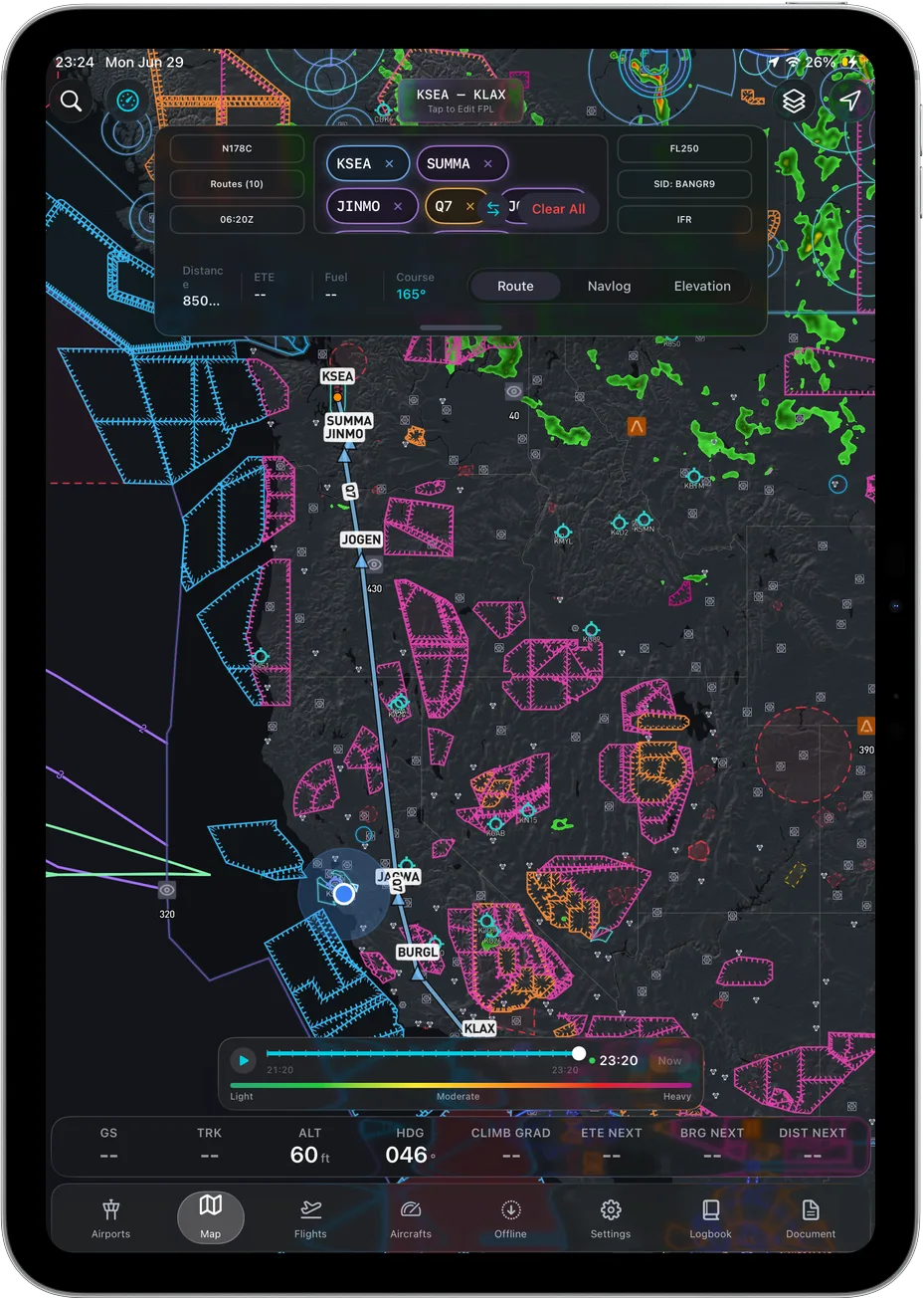 One map: position, airspace, terrain and your route.
Key features: 3D terrain, geo-referenced FAA charts including VFR Sectionals, Terminal Area Charts and IFR Enroute Low, High and Area, the full weather stack (METAR, TAF, radar, winds aloft, AIRMET, SIGMET), live traffic, airport information, geo-referenced taxi diagrams, and full offline caching including the 3D map. Own-ship is a heading-up 2D puck; the terrain around it is what carries the dimensionality.
Who it suits: Students on an iPad or iPhone who do not want a tier to outgrow. Nothing is held back, so when you start the instrument rating and need enroute charts, you do not get a bill. Most of your flying right now is low, slow and close to the ground in country you do not know yet, which is exactly where seeing terrain beats reading it. And full offline caching matters more at a training field with one bar than it does anywhere else.
Pricing: One plan, $59.99 the first year and $89.99 a year after that. No tiers, no IFR add-on.
Sourced note: This is our own product, so treat it as vendor copy rather than review, priced from our own App Store listing as of August 26, 2026. The straight version of the trade: Ascent launched in August 2026, so it does not have the decade of depth the incumbents do. It is iPad and iPhone only, with no Android version. Own-ship is a 2D heading-up puck, not a 3D aircraft model. Geo-referenced approach plates are not part of the chart set today, so if you are shopping for the instrument rating rather than primary training, price that in.
ForeFlight
Key features: The deepest published feature set in the category, in three tiers, with Synthetic Vision, Geo-Referenced Approach Charts and Hazard Advisor listed from Essential up and 3D View listed under Premium.
Who it suits: Students at a school that already runs on it, and anyone who wants the app their CFI can teach from without translating.
Pricing: $130 Starter, $260 Essential, $390 Premium per year.
Sourced note: Tiers, prices and feature placement are from ForeFlight's own pricing page (checked August 26, 2026). ForeFlight's support site states that each new App Store download comes with a 30-day trial of the Premium feature set (support.foreflight.com, checked August 26, 2026).
Garmin Pilot
Key features: Integration with Garmin panel avionics, a published US Standard and US Premium split, and an Android app alongside iOS.
Who it suits: Students training in aircraft with Garmin panels, and anyone whose tablet is not an iPad.
Pricing: $109.99 US Standard, $209.98 US Premium per year.
Sourced note: Tier names and prices are from Garmin's own product listing, checked August 8, 2026.
FlyQ EFB
Key features: AR view and synthetic vision, with VFR and IFR sold as separate tiers.
Who it suits: VFR students who like the camera overlay and are willing to step up a tier later.
Pricing: $99.99 VFR, $199.99 with IFR.
Sourced note: Prices and features from Seattle Avionics' own published listing, checked August 26, 2026.
iFly EFB
Key features: iOS, Android and Windows, with IFR data as a separate purchase.
Who it suits: Students who fly with a mix of hardware and want one app across it.
Pricing: $94.99 VFR, plus $55 for IFR data, plus $29.99 for cross-platform use.
Sourced note: Plan structure and add-on prices are from iFly's own plan page, checked August 26, 2026.
WingX
Key features: The cheapest paid entry in this list, with Advanced IFR sold separately.
Who it suits: Students who want a paid app on a tight budget and are years from the instrument rating.
Pricing: $74.99 a year, with Advanced IFR as a separate subscription.
Sourced note: Both subscription prices are from WingX's own App Store listing, checked August 26, 2026.
FltPlan Go
Key features: Free planning and filing, Garmin-owned.
Who it suits: Any student whose budget is already spent on instruction and rental.
Pricing: Free.
Sourced note: Free pricing and Garmin ownership from the app's own App Store listing, checked August 26, 2026.
Avare
Key features: Free FAA charts, open source.
Who it suits: Android students on a zero budget.
Pricing: Free.
Sourced note: Android-only availability and free pricing from the app's own Google Play listing, checked August 26, 2026.
Where ForeFlight still wins
Specific, because a vague concession is worthless.
Your CFI already knows it. If your instructor teaches on ForeFlight, every explanation lands without translation, and every "tap here" works on your screen too. That is worth more during primary training than any feature we could ship, and we cannot give it to you.
Approach charts when the rating comes. ForeFlight's own pricing page lists Geo-Referenced Approach Charts under Essential and Premium (checked August 26, 2026). Ascent EFB does not have them at all. If you are buying one app to carry you through the instrument rating, that is a real gap on our side.
Trying it before you commit. ForeFlight's support site says each new App Store download comes with a 30-day trial of the Premium feature set (checked August 26, 2026).
And where Garmin Pilot still wins: if your school's aircraft are behind Garmin panels, or your tablet runs Android, Garmin publishes both the panel integration and the Android app, and we publish neither.
Bluntly: if your flight school issues you a ForeFlight login, or your CFI teaches on it, buy ForeFlight and stop reading comparison posts. Fluency with the app in the airplane beats a better app you are learning alone.
How to actually choose
Several vendors publish a trial on their own pages, so check the ones you are considering. Then pick two and use each for a week of real lessons. You cannot read feel off a spec sheet, so stop trying and go fly with them.
- Plan a cross-country in each and see which one you finish faster.
- Brief a marginal weather day in each and see which picture you trust.
- Put it in airplane mode before a lesson and see what survives.
- Fly toward rising terrain and see which one makes the answer obvious.
Then commit and stop shopping. Fluency with one app beats owning the best one.
Frequently asked questions
Do student pilots need a paid EFB?
No. Avare and FltPlan Go are free and usable for primary training. A paid app buys better weather presentation, terrain awareness and support, which most students find worth it by the time they start cross-countries.
What is the cheapest EFB that still has everything?
Ascent EFB at $59.99 the first year, $89.99 after. It is one plan, so 3D terrain, geo-referenced charts, full weather, live traffic and offline caching are all included rather than split across tiers. WingX is cheaper at renewal ($74.99) but sells IFR as a separate subscription, per its own App Store listing checked August 26, 2026.
Should I just get ForeFlight since everyone uses it?
It is an excellent app, and if your instructor and flying club run on it, that shared fluency is worth real money. Just price the tier that carries what you need rather than assuming the entry plan covers it.
Will my instructor let me use an EFB?
Almost certainly, alongside paper, not instead of it. Every EFB is a supplemental aid to situational awareness, and your instructor will want you able to fly the airplane without one.
Written by Vincent Wu, founder of Ascent EFB, updated August 26, 2026. Prices were read from each vendor's published pages and re-checked on August 26, 2026, with Garmin checked August 8, 2026, and they change over time. Ascent is our product; claims about other apps are limited to what they publish themselves, with the date each page was read. Any EFB is a supplemental aid to situational awareness, and final authority rests with the pilot in command.
Try Ascent EFB
Free for 30 days, then $59.99 your first year
One plan with everything in it: 3D terrain, geo-referenced FAA charts, the full weather stack and live traffic, all cached offline. $89.99 a year after the first. One trial per account, no card needed to look around.
Start a 30-day trial